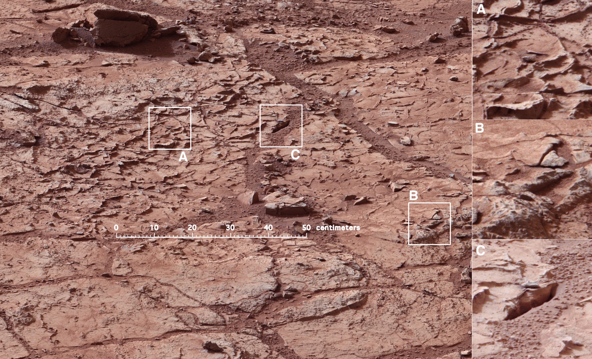
The rocky surface of Mars has turned up some rather interestingly-shaped objects in the past. First there was the Martian rat, followed shortly thereafter by the Martian donut; and very recently, the Martian thighbone. And in this latest case, the Curiosity rover has spotted what appears to be a perfectly-round ball. Even more interesting is the fact that this sphere may be yet another indication of Mars’ watery past.
The rock ball was photographed on Sept. 11 – on Sol 746 of the rover’s mission on Mars – while Curiosity was exploring the Gale Crater. One of Curiosity’s cameras captured several images of the centimeter-wide ball as part of the stream of photographs was taking. The scientists working at the Mars Science Laboratory based at NASA’s Jet Propulsion Laboratory (JPL), immediately began to examine it for indications of what it could be.
As Ian O’Neill of Discovery News, who spoke with NASA after the discovery, wrote:
According to MSL scientists based at NASA’s Jet Propulsion Laboratory (JPL) in Pasadena, Calif., the ball isn’t as big as it looks — it’s approximately one centimeter wide. Their explanation is that it is most likely something known as a “concretion”… and they were created during sedimentary rock formation when Mars was abundant in liquid water many millions of years ago.
Curiosity has already found evidence of water at a dig site in Yellowknife Bay, which took place shortly after it landed in the Gale Crater two years ago. In addition, this is not the first time a Mars rover has found rocky spheres while examining the surface. In 2004, NASA’s Opportunity rover photographed a group of tiny balls made of a ferrous mineral called hematite. Opportunity photographed still more spheres, of a different composition, eight years later.
The spheres likely formed through a process called “concretion”, where minerals precipitate within sedimentary rock, often into oval or spherical shapes. When the rock erodes due to wind or water, it leaves the balls of minerals behind and exposed. If in fact concretion caused the Mars spheres, then they would be evidence there was once water on the planet. However, some scientists believe the rock balls might be leftover from meteorites that broke up in the Martian atmosphere.
Curiosity is now at the base of Mount Sharp (Aeolis Mons) – The 5.6 km-high (3.5 mile) mountain in the center of Gale Crater – scientists are excited to commence the rover’s main science goal. This will consists of more drilling into layered rock and examining the powder so scientist can gain an idea about how habitable the Red Planet was throughout its ancient history, and whether or not it may have been able to support microbial life.
Mission managers will need to be careful as the rover has battered wheels from rougher terrain than expected. Because of this, the rover will slowly climb the slope of Mount Sharp driving backwards, so as to minimize the chance of any further damage. The Mars Reconnaissance Orbiter (MRO) will also be on hand to help, photographing the route from above to find the smoothest routes.
Despite the wear and tear that the little rover has experienced in its two years on the Martian surface, it has discovered some amazing things and NASA scientists anticipate that it will accomplish much more in the course of its operational history. And as it carried on with its mission to decode the secrets of Mars, we can expect it will find lots more interesting rocks – spherical, rat-shaped, ringed, femur-like, or otherwise.
It certainly has been a momentous few weeks for space exploration! Between the final weeks of August and the month of September, we’ve seen the Curiosity rover reach Mount Sharp, the Rosetta spacecraft created the first full map of a comet’s, the completion of the Orion space module, and the MAVEN orbiter reach Martian orbit. And before the month is out, India’s Mars Orbiter Mission (MOM) will also arrive in orbit around the Red Planet.
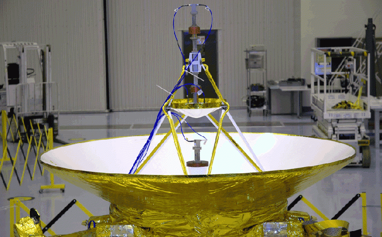
Despite all these developments, that occurred (relatively) close to home, there was even more news to be had, coming all the way from the edge of the Solar System no less. At the tail end of August, NASA announced that the New Horizons space probe passed Neptune orbit and is on its way to Pluto. Launched back in 2006 for the purpose of studying the dwarf planet, the probe is expected to arrive on July 14th of next year.
NASA says that the the craft passed the Neptunian orbit at 10:04 pm EDT on Monday August 25th, which coincided with the 25th anniversary of Voyager 2’s flyby of Neptune in 1989. But where Voyager came within 4,950 km (3,080 mi) of the gas giant, the New Horizons craft passed by at a distance of 3.96 billion km (2.45 billion mi). The spacecraft is now almost 4.42 billion km (2.75 billion mi) from Earth, and is the fastest man-made object ever sent into space.
Nevertheless, New Horizons’ Long Range Reconnaissance Imager (LORRI) was still able to capture images of Neptune and its giant moon Triton. As you can see from the image below, Neptune appears as the large white disc in the middle, while Triton is the small black dot passing in front and sitting slightly to the ride. NASA says that Triton may be very similar to Pluto and the information gathered by Voyager 2 may prove helpful in the coming encounter.
Ralph McNutt of the Johns Hopkins University Applied Physics Laboratory.
There is a lot of speculation over whether Pluto will look like Triton, and how well they’ll match up. That’s the great thing about first-time encounters like this – we don’t know exactly what we’ll see, but we know from decades of experience in first-time exploration of new planets that we will be very surprised.
The first mission in NASA’s New Frontiers program, the New Horizons mission was launched on January 19, 2006 atop an Atlas V rocket from Cape Canaveral, Florida. It broke the record for the fastest man-made object on lift off with a speed of 58,536 km/h (36,373 mph). The 478 kg (1,054 lb) spacecraft was sent on a 9.5-year mission to fly by Pluto – a distance so far that radio signals from the nuclear-powered probe take four hours to reach Earth.
Sent on a slingshot trajectory using the gravitational pull of Jupiter, which tacked on another 14,480 km/h (9,000 mph) to its speed, New Horizons will pass Pluto in July of next year at a distance of 13,000 km (8,000 mi). After this encounter, it will continue on out of the Solar System, during which it will be in the distant Kuiper belt studying one or more Kuiper belt objects (KBOs).
Though this will still not rival Voyager 1’s accomplishments, which left our Solar System last year, New Horizons promises to gather far more information on the Outer Solar System and what lies beyond. All of this will come in mighty handy when at last, humanity contemplates sending manned missions into deep space, either to Alpha Centauri or neighboring exoplanets.
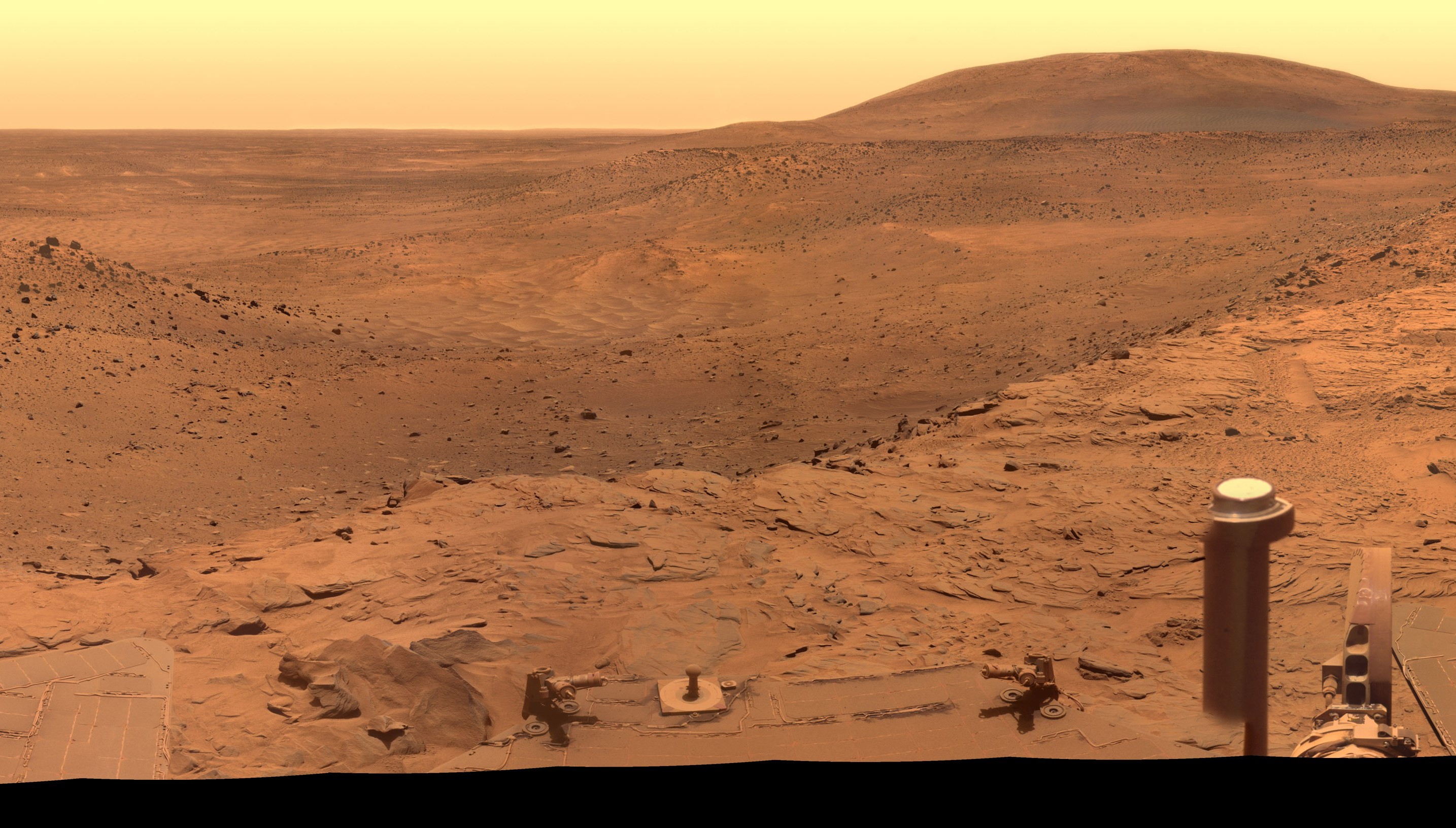
After two years exploring the Martian surface, the Curiosity Rover has finally reached its primary science destination – the foot of Mount Sharp, officially known as Aeolis Mons. Now that it’s there, it will begin its ascent of the rock formation, drill into rocks and analyze the different strata in the hopes of learning more about the history of the Red Planet. This is an event a long time in the making, and may prove to yield some of the greatest scientific discoveries ever made.
Located in the heart of the Gale Crater, Mount Sharp is like a layer cake, holding a chronology of past events reaching back billions of years. Because of this, it is an ideal place to find evidence that the Martian surface and atmosphere were once capable of supporting life. It took two years and one month for Curiosity reach the foot of this mountain, which lies some 5500 meters (18,000 feet) above the floor of Gale Crater.
The mountain is the central peak in a crater that measures 154 km/96 miles in diameter and which was formed when a meteor impacted the surface between 3.5 and 3.8 billion years ago. Beyond a certain size, and depending on the gravity of the planet, craters like this all have a central peak. But Mount Sharp represents something much more, otherwise NASA and the Jet Propulsion Laboratory wouldn’t be bothering with it.
Basically, Mars scientists believe that after its creation, the Gale crater was completely filled with sedimentary material from a series of huge floods, or by dust and ice deposits like those that happened at the Martian polar caps. The deposition over 2 billion years left a series sedimentary layers that filled the crater. Following the deposition of the layers, there was a long period of erosion which has finally led to the condition of the crater today.
The erosion by some combination of aeolean (wind) forces and water (additional flooding), scooped out the huge crater, re-exposing most of the original depth. However, covering the original central peak are many sedimentary layers of debris. Gale crater’s original central peak actually remains completely hidden and covered by sedimentation. And it is this that attracted scientists with the Curiosity rover to the base of Mount Sharp.
Within the sedimentary layers is a sequential record of the environmental conditions on Mars going back over 2 billion years. While at the base, Curiosity will be able to examine the oldest sedimentary layers; but as it climbs the flanks of the mountain, it will be able to step forward in time. Each layer and its age will reveal information such as how much water was present, whether the water was alkaline or acidic, if there is any organic compounds.
The discovery of organic compounds on Mount Sharp could be “Earth shaking”, since the discovery of organics is of very high importance to this mission. Already, over the two year trek, Curiosity has seen numerous signs of the flow of water and sedimentation. Interestingly enough, evidence began to turn up way back in Yellowknife Bay — one of its first destinations, which it visited almost two years ago. But as of yet, signs of organic compounds have remained illusive.
What’s more, Curiosity sadly lacks the necessary equipment to look for evidence of microbial fossils or other signatures of life. Fortunately, the next rover – the Mars 2020 rover – will be equipped with the necessary tools to work out whether Mars ever harbored life. In any case, because of the lack of organic compounds in Yellowknife, NASA decided to continue to Mount Sharp, which is currently the best place to dig up scientific data about Mars’ past.
Curiosity is currently at the base of Mount Sharp, in a region called the Pahrump Hills, where it will continue on to the Murray Formation. Once there, it will take a drill sample of some rock and then continue up Mount Sharp towards the Hematite Ridge where two drill sites await. This farthest site is about 8 km (5 mi) away from its present position, and Curiosity has driven only 9 km since it landed in 2012. So there’s plenty of trekking and work ahead!
One of the greatest challenges is finding a path that will reduce the stress on Curiosity’s wheels, which have been put through some serious wear and tear in the past two years. Because of this, the rover is being driven in reverse for the time being, and the team is looking the path with the least amount of sharp rocks. However, the Mars Curiosity remains confident that the mobility system will be capable of surviving the ten year life span of the rover’s power supply.
And be sure to check out this “Curiosity Rover Report” that talks about this historic accomplishment, courtesy of NASA’s Jet Propulsion Laboratory:
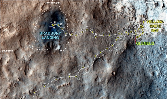
Earlier this month, Curiosity marked its second year on the Red Planet, and this anniversary comes amidst plenty of exciting news and developments. Ever since the rover touched down at the Bradbury Landing site inside the Gale Crater on August 5, 2012 at 10:31 pm PDT (August 6, 05:31 GMT), it has been busily searching for signs that life once existed on Earth’s neighbor. And as it enters into its third year of exploration, it is getting closer to accomplishing this lofty goal.
The nuclear-powered explorer is the largest, most advanced rover ever built. And since nothing like it had ever flown before and the maintenance facility was over 160 million kilometers (1oo million miles) away, the first months that Curiosity spent on Mars involved an array of system tests before it took it first tentative rolls across the Martian sands on its roundabout path to Mount Sharp.
Curiosity’s main mission was to find out if there are any places on Mars where life could have once existed – specifically, areas displaying minerals and geology that could have been produced by water. The Bradbury Landing site, where it touched down, turned out to be very close to an ancient dried lake bed in an area named Yellowknife Bay. According to NASA, this lake bed may have been able to sustain microbial life billions of years ago.
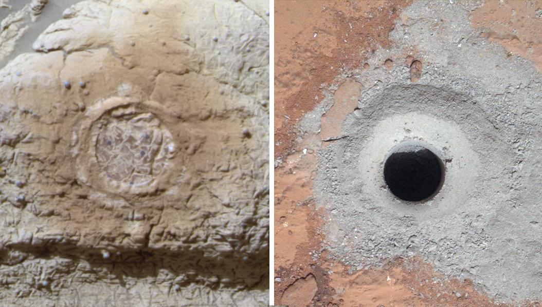
And then, barely six months after landing, the scientists struck gold when they drilled into a rock outcrop named “John Klein” at Yellowknife Bay and unexpectedly discovered the clay bearing minerals on the crater floor. This was the first instance of Curiosity finding clay-bearing minerals. or phyllosilicates, which are a key sign that organic molecules could exist on the planet.
As Curiosity Project Scientist John Grotzinger of the Caltech said in a statement to mark the anniversary:
Before landing, we expected that we would need to drive much farther before answering that habitability question. We were able to take advantage of landing very close to an ancient streambed and lake. Now we want to learn more about how environmental conditions on Mars evolved, and we know where to go to do that.
Compared to its first year, which was marked by many firsts – such as the first drilling operation on Mars, the first laser firing, and first UV night scans – Curiosity’s second year on the Red Planet has been more routine. However, it hasn’t been without its share of excitement. In February, the rover cleared a dune that blocked its progress and in July it negotiated a detour around rocky terrain at Zabriskie Plateau.
However, by far, the majority of the rovers second Earth year on the Red Planet has been spent driving as fast as possible towards a safe entry point to the slopes of Mount Sharp. To date, Curiosity’s odometer totals over 9.0 kilometers (5.5 miles) since landing inside Gale Crater on Mars in August 2012, and her on board camera has snapped over 174,000 images – many of which have been transformed into panoramic shots of the surface.
The desired destination for the rover is now about 3 kms (2 miles) southwest of its current location. This consists of a bedrock unit that for the first time is actually part of the humongous mountain known as Mount Sharp. As the primary destination on her ongoing mission, this layered mountain in the Gale Crater towers 5.5 kilometers (3.4 miles) into the Martian sky, and is believed to hold the most compelling evidence of life yet.
The sedimentary layers in the lower slopes of Mount Sharp are the principal reason why the science team specifically chose Gale Crater as the primary landing site. Using high resolution spectral observations collected by NASA’s powerful Mars Reconnaissance Orbiter (MRO), they were able to determine the presence of deposits of clay-bearing minerals. or phyllosilicates, a key sign that organic molecules could exist on the planet.
In late July of this year, the rover arrived in an area of sandy terrain called “Hidden Valley” which is on the planned route ahead leading to “Pahrump Hills”. Scientists anticipated that the outcrops here would offer a preview of a geological unit that is part of the base of Mount Sharp for the first time since landing. However, the sharp edged rocks caused significant damage to the rovers six aluminum wheels, forcing it to make a detour.
This detour will take Curiosity to a similar site called “Bonanza King” to carry out its fourth drilling mission. According to NASA, this is no great loss because the two areas are geologically connected and the space agency is keen to look at a formation that is different from the crater floor formations encountered so far. Engineers are studying Bonanza King to see if its is suitable for drilling by assessing whether or not the plates seen on the surface are loose.
When drilling operations resume, NASA will study alternative routes to Mount Sharp and determine how well the rover’s wheels can handle sand ripples. However, as Dr. Jim Green, NASA’s Director of Planetary Sciences, said during an interview during the rover’s second anniversary in Washington, DC : “Getting to Mount Sharp is the next big step for Curiosity and we expect that in the Fall of this year.”
Godspeed, little rover! And I do hope that it finds the long-sought-after organic particles it has been looking for since the mission began. This discovery will not only show that life once existed on Mars (and still does in some capacity) it will also be one of the greatest scientific finds of all time, and maybe even serve as the starting point for ensuring that it can exist again.
As the exploration of Mars goes on, the small army of robotic rovers, satellites and orbiters continue to provide us with information, photographs and discoveries that remind us of how great a mystery the Red Planet truly is. For instance, in the past month, two major stories have been announced concerning the nature of Martian soil, its ancient history, and some of the more exciting moments in it’s exploration.
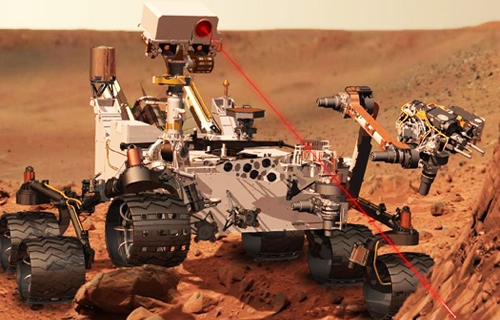
For example, Curiosity made news as its high resolution camera caught an image of sparks being generated as it zapped a Martian rock. In it’s lifetime, the rover has used its million watt Chemistry and Camera (ChemCam) laser to zap over 600 rock or soil targets as part of its mission. However, this was the first time that the rover team was able to get the arm-mounted Mars Hand Lens Imager (MAHLI) to capture the action as it occurred.
The ChemCam laser is used to determine the composition of Martian rocks and soils at a distance of up to 8 meters (25 feet). By hitting targets with several high-energy pulses, it is able to yield preliminary data for the scientists and engineers back at Earth to help them decide if a target warrants a closer investigation and, in rare cases, sampling and drilling activities.
ChemCam works through a process called laser-induced breakdown spectroscopy. The laser hits a target with pulses to generate sparks, whose spectra provide information about which chemical elements are in the target. Successive laser shots are fired in sequence to gradually blast away thin layers of material. Each shot exposes a slightly deeper layer for examination by the ChemCam spectrometer.
As Curiosity fired deeper into the target rock – named “Nova” – it showed an increasing concentration of aluminum as the sequential laser blasts penetrated through the uninteresting dust on the rock’s surface. Silicon and sodium were also detected. As Sylvestre Maurice, ChemCam’s Deputy Principal Investigator at the Research Institute in Astrophysics and Planetology, said in a statement:
This is so exciting! The ChemCam laser has fired more than 150,000 times on Mars, but this is the first time we see the plasma plume that is created… Each time the laser hits a target, the plasma light is caught and analyzed by ChemCam’s spectrometers. What the new images add is confirmation that the size and shape of the spark are what we anticipated under Martian conditions.
During it’s first year on Mars, Curiosity has already accomplished its primary objective of discovering a habitable zone on Mars that contains the minerals necessary to support microbial life billions of years ago when Mars was wetter and warmer. Currently, the rover is driving swiftly to the base of Mount Sharp at the center of Gale Crater, where it hopes to find more.
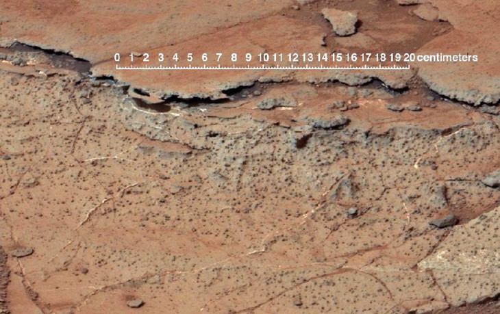
In that same vein, according to new geological information obtained by Curiosty’s images and soil examinations, samples that were pulled out of a crater that is estimated to be some 3.7 billion years old contain more evidence that Mars was once much warmer and wetter. These findings were announced in a recent paper published in the online edition of Geology by University of Oregon geologist Gregory Retallack.
Unlike Earth, the Martian landscape is littered with loose rocks from impacts or layered by catastrophic floods. However, recent images from Curiosity from the Gale Crater reveal Earth-like soil profiles with cracked surfaces lined with sulfate, ellipsoidal hollows and concentrations of sulfate comparable with soils in Antarctica’s McMurdo Dry Valleys and Chile’s Atacama Desert.
Retallack, the paper’s lone author, studied mineral and chemical data published by researchers closely tied with the Curiosity mission. As a professor of geological sciences and co-director of paleontology research at the UO Museum of Natural and Cultural History, he internationally known as an expert on the recognition of paleosols – ancient fossilized soils contained in rocks.
As he explains in the paper:
The pictures were the first clue, but then all the data really nailed it. The key to this discovery has been the superb chemical and mineral analytical capability of the Curiosity Rover, which is an order of magnitude improvement over earlier generations of rovers. The new data show clear chemical weathering trends, and clay accumulation at the expense of the mineral olivine, as expected in soils on Earth. Phosphorus depletion within the profiles is especially tantalizing, because it attributed to microbial activity on Earth.
The ancient soils do not prove that Mars once contained life, but they do add to growing evidence that an early, wetter and warmer Mars was more habitable than the planet has been in the past 3 billion years. Surface cracks in the deeply buried soils suggest typical soil clods. Vesicular hollows, or rounded holes, and sulfate concentrations, he said, are both features of desert soils on Earth.
Since Curiosity is currently on its way to Mount Sharp, future missions will be needed to fully explore these features. But as Retallack explained, the parallels with Earth are quite exciting:
None of these features is seen in younger surface soils of Mars. The exploration of Mars, like that of other planetary bodies, commonly turns up unexpected discoveries, but it is equally unexpected to discover such familiar ground.
The newly discovered soils indicate that more benign and habitable soil condition existed on Mars than previously expected. What’s more, their dating to 3.7 billion years ago places them within a transition period when the planet went from an early, benign water cycle to the acidic and arid Mars of today. This is especially important since major changes were taking place on Earth at around the same time.
Roughly 3.5 billion years ago, life on Earth is believed to have emerged and began diversifying. But some scientists have theorized that potential evidence that might indicate that life existed on Earth earlier may have been destroyed by tectonic activity, which did not occur on Mars. Basically, it may offer some credence to the theory that while flourished on Earth, it originated on Mars.
One person who supports this theory is Steven Benner of the Westheimer Institute of Science and Technology in Florida. In the past, he has speculated that life is more likely to have originated on a soil planet like Mars than a water planet like Earth. In an email interview with Science Daily, Benner wrote that Retallack’s paper:
[S]hows not only soils that might be direct products of an early Martian life, but also the wet-dry cycles that many models require for the emergence of life.
So in addition to shedding light on the mysteries of Mars, Curiosity has also been pivotal in addressing some major questions which only increase the mystery of our own existence. Did life as we know it originate on Mars but flourish on Earth? Are there still some remnants of this microbial “Eden” being preserved deep within the soil and rocks? And could life exist there again some day?
All good questions that will no doubt keep robotic rovers, orbiters, landers, and even manned missions busy for many decades to come! In the meantime, check out the video from NASA’s Jet Propulsion Laboratory of Curiosity’s spark-generating laser blast being caught on tape:
After ten years in service (when it wasn’t supposed to last longer than nine months), one would think that left for the Opportunity rover to do. And yet, Opportunity is still hard at work, thanks in no small part to its solar panels being their cleanest in years. In its latest research stint, NASA’s decade-old Mars Exploration Rover Opportunity is inspecting a section of crater-rim ridgeline chosen as a priority target due to evidence of a water-related mineral.
Orbital observations of the site by another NASA spacecraft – the Mars Reconnaissance Orbiter (MRO) – found a spectrum with the signature of aluminum bound to oxygen and hydrogen. Researchers regard that signature as a marker for a mineral called montmorillonite, which is in a class of clay minerals (called smectites) that forms when basalt is altered under wet and slightly acidic conditions. The exposure of it extends about 240 meters (800 feet) north to south on the western rim of Endeavour Crater.
The detection was made possible using the MRO’s Compact Reconnaissance Imaging Spectrometer for Mars (CRISM) combined with rover observations some 3 kms (2 miles) north on the crater’s western rim. Rocks exposed there contain evidence for an iron-bearing smectite – called nontronite – as well as for montmorillonite. That site yielded evidence for an ancient environment with water that would have been well-suited for use by microbes, evidence that could boost our understanding of what Mars looked like billions of years ago.
Opportunity reached the northern end of the montmorillonite-bearing exposure last month – a high point known as “Pillinger Point.” Opportunity’s international science team chose that informal name in honor of Colin Pillinger (1943-2014), the British principal investigator for the Beagle 2 project, which attempted to set a research lander on Mars a few weeks before Opportunity landed there in January of 2004.
Opportunity Principal Investigator Steve Squyres, of Cornell University, had this to say about Pillinger:
Colin and his team were trying to get to Mars at the same time that we were, and in some ways they faced even greater challenges than we did. Our team has always had enormous respect for the energy and enthusiasm with which Colin Pillinger undertook the Beagle 2 mission. He will be missed.
Though selected as a science destination, Pillinger Point also offers a scenic vista from atop the western rim of Endeavour Crater, which is about 22 kms (14 miles) in diameter. The picture below shows a section of a color shot taken by Opportunity’s panoramic camera (Pancam) upon arrival. A full-size view of this picture can be seen by going to NASA’s Jet Propulsion Laboratory Mars Exploration Rovers webpage.
Initial measurements at this site with the element-identifying alpha particle X-ray spectrometer at the end of Opportunity’s arm indicate that bright-toned veins in the rock contain calcium sulfate. Scientists deduce this mineral was deposited as water moved through fractures on Endeavour’s rim. The rover found similar veins of calcium sulfate farther north along the rim while investigating there earlier last month.
As Opportunity investigated this site and other sites farther south along the rim, the rover had more energy than usual. This was due to the solar cells being in rare form, says Opportunity Project Manager John Callas of NASA’s Jet Propulsion Laboratory:
The solar panels have not been this clean since the first year of the mission. It’s amazing, when you consider that accumulation of dust on the solar panels was originally expected to cause the end of the mission in less than a year. Now it’s as if we’d been a ship out at sea for 10 years and just picked up new provisions at a port of call, topping off our supplies.
Both Opportunity and its rover twin, Spirit, benefited from sporadic dust-cleaning events in past years. However, on the ridge that Opportunity has been navigating since late 2013, winds have removed dust more steadily, day by day, than either rover has experienced elsewhere. The rover’s signs of aging – including a stiff shoulder joint and occasional losses of data – have not grown more troublesome in the past year, and no new symptoms have appeared.
JPL’s Jennifer Herman, power-subsystem engineer added:
It’s easy to forget that Opportunity is in the middle of a Martian winter right now. Because of the clean solar arrays, clear skies and favorable tilt, there is more energy for operations now than there was any time during the previous three Martian summers. Opportunity is now able to pull scientific all-nighters for three nights in a row — something she hasn’t had the energy to do in years.
During Opportunity’s first decade on Mars and the 2004-2010 career of Spirit, NASA’s Mars Exploration Rover Project yielded a range of findings about wet environmental conditions on ancient Mars – some very acidic, others milder and more conducive to supporting life. These findings have since been supplemented and confirmed by findings by the Curiosity Rover, which hopes to find plenty of clues as to the nature of possible life on Mars when it reaches Mount Sharp later this summer.
This August, the Curiosity Rover will be celebrating its second anniversary of roving around the Red Planet. And ever since it made landfall, Curiosity and the Mars Science Laboratory has repeatedly uncovered signs that Mars was once very like Earth. Basically, it has become undeniable that water once flowed freely over the surface of this barren and uninhabitable world. And this finding, much to the delight of futurists and sci-fi enthusiasts everywhere, is likely to pave the way for human settlement.
Liquid water disappeared from Mars’ surface millions of years ago, leaving behind tantalizing clues about the planet’s ancient past—clues that the MSL has been deciphering for the past 22 months. This began last year when Curiosity found rounded pebbles in the Glenelg region, an indication that a stream once flowed at the site. This was followed by the discovery of rocky outcroppings where the remains of an ancient stream bed consisting of water-worn gravel that was washed down from the rim of Gale Crater.
The rover has since moved to a location about 6.5 kilometers (4 miles) away from the Gale Crater landing site, where scientists expect to make even more discoveries. The new location is named Kimberly, after a region of northwestern Australia. As Dawn Sumner, a UC Davis geology professor and co-investigator for NASA’s Mars Science Laboratory team, explained:
Our findings are showing that Mars is a planet that was once a whole lot like Earth. All the rocks we’ve seen on this mission are sediments that have been deposited by water. We’ve found almost no sandstone deposited by wind.
Sumner is working from Curiosity mission control at NASA’s Jet Propulsion Laboratory in Pasadena while on sabbatical from UC Davis, exploring whether the planet ever had an environment capable of supporting microbial life. She is also one of several UC scientists and engineers who have been vital to the success of the Curiosity mission, which is part of NASA’s long-term plan to pave the way for sending astronauts to Mars.
In that vein, research continues here on Earth to see exactly what kind of life can survive in the harsh Martian environment. And now, research suggests that methanogens – among the simplest and oldest organisms on Earth – could survive on Mars. These microorganisms are typically found in swamps and marshes, where they use hydrogen as their energy source and carbon dioxide as their carbon source to produce methane (aka. natural gas).
As an anaerobic bacteria, methanogens don’t require require oxygen or organic nutrients to live, and are non-photosynthetic. Hence, they would be able to exist in sub-surface environments and would therefore be ideal candidates for life on Mars. Rebecca Mickol, a doctoral student in space and planetary sciences at the University of Arkansas, subjected two species of methanogens to Martian conditions to see how they would fair on the Red Planet.
These strains included Methanothermobacter wolfeii and Methanobacterium formicicum, both of which survived the Martian freeze-thaw cycles that Mickol replicated in her experiments. This consisted of testing the species for their ability to withstand Martian freeze-thaw cycles that are below the organisms’ ideal growth temperatures. As she explained it:
The surface temperature on Mars varies widely, often ranging between minus 90 degrees Celsius and 27 degrees Celsius over one Martian day. If any life were to exist on Mars right now, it would at least have to survive that temperature range. The survival of these two methanogen species exposed to long-term freeze/thaw cycles suggests methanogens could potentially inhabit the subsurface of Mars.
Mickol conducted the study with Timothy Kral, professor of biological sciences in the Arkansas Center for Space and Planetary Sciences and lead scientist on the project. She presented her work at the 2014 General Meeting of the American Society for Microbiology, which was held from May 17th to 20th in Boston.
The two species were selected because one is a hyperthermophile, meaning it thrives under extremely hot temperatures, and the other is a thermophile, which thrives under warm temperatures. Since the 1990s, Kral has been studying methanogens and examining their ability to survive on Mars. In 2004, scientists discovered methane in the Martian atmosphere, and immediately the question of the source became an important one. According to Kral:
When they made that discovery, we were really excited because you ask the question ‘What’s the source of that methane?. One possibility would be methanogens.
Understanding the makeup of Mars atmosphere and ecology is another major step towards ensuring that life can exist there again someday. From Red Planet, to Blue Planet, to Green Planet… it all begins with a fundamental understanding of what is currently able to withstand the Martian environment. And once this foundation is secured, our ecologists and environmental engineers can begin contemplating what it will take to create a viable atmosphere and sustainable sources of water there someday.
April was a busy month for the very photo-talented (and photogenic) Curiosity Rover. In addition to another panoramic shot of the Martian landscape – which included Curiosity looking back at itself, making it a “selfie” – the rover also managed to capture a night-sky image that captured two minor planets and the Martian moon of Deimos in the same picture. At a time when Curiosity and Opportunity are both busy on long-haul missions to find evidence of life, these latest pictures remind us that day-to-day operations on Mars are still relevant.
The first shot took place on April 20th (Sol 606), when rover scientists used the Mast Camera to capture the minor planets of Ceres and Vesta, as well as the moon of Deimos, in the same frame. Ceres is a minor planet with a diameter of about 950 km, and is the largest object in the main asteroid belt. With a diameter of about 563 km, Vesta is the third-largest object in the asteroid belt. Deimos, meanwhile, is the smaller of Mars’ two moons, with a mean radius of 6 km.
In the main portion of the new image (seen above), Vesta, Ceres and three stars appear as short streaks due to the duration of a 12-second exposure. In other camera pointings the same night, the Curiosity’s camera also imaged Phobos and the planets Jupiter and Saturn, which are shown as insets on the left. Dr Mark Lemmon from Texas A&M University, a Curiosity team member, explained:
this imaging was part of an experiment checking the opacity of the atmosphere at night in Curiosity’s location on Mars, where water-ice clouds and hazes develop during this season… The two Martian moons were the main targets that night, but we chose a time when one of the moons was near Ceres and Vesta in the sky.
Deimos was much brighter than the visible stars, Vesta and Ceres in the same part of the sky, in the main image. The circular inset covers a patch of sky the size that Earth’s full moon appears to observers on Earth. At the center of that circular inset, Deimos appears at its correct location in the sky, in a 0.25 second exposure.
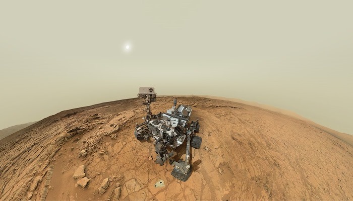
As for the latest in Curiosity’s long-line of panoramic self-portraits, this one comes to us courtesy of Jason Major. As a graphic designer and amateur space explorer, Major assembled the picture from about the dozen or so images acquired with the rover’s Mars Hand Lens Imager (MAHLI) instrument on April 27-28, 2014 (Sol 613). In the background, one can see the 5.5-km-high (3.4 miles) Mount Sharp (Aeolis Mons) that sits in the center of the Gale Crater.
One thing that Major noted about the picture he assembled is the way the cylindrical RUHF antenna and the bit of the RTG that is visible in the lower center seem to form a “toothy (if slightly dusty) grin”. But, as he stated:
…with almost 21 Earth-months on Mars and lots of discoveries already under her robot belt, Curiosity (and her team) certainly have plenty to smile about!
And the best is likely to still be coming. As we speak, Curiosity is making its way towards Mount Sharp and is expected to arrive there sometime in August. As the primary goal in its mission, Curiosity set off for this destination back in June after spending months studying Glenelg area. She is expected to arrive at the foot of the mountain in August, where she will begin drilling in an effort to study the mountain’s vast caches of minerals – which could potentially support a habitable environment.
If Curiosity does find evidence of organic molecules in this cache, it will be one of the greatest scientific finds ever made, comparable only to the discovery of hominid remains in the Olduvai Gorge, or the first recorded discovery of dinosaur remains. For not only will we have definitive proof that life once existed on Mars, we will know with some certainly that it may again someday…
Stay tuned for more news from the Red Planet. And in the meantime, keep on trucking Curiosity!
Mars is a interesting and varied place, with enough mysteries to sate appetites both subtle and gross. But as we come to study it up close and get to know it better, a peculiar challenge arises. Basically, there are thousands of geological features on the Martian surface that don’t yet have names. Up until now, only those mountains, hills and craters that are observable from space have been designated.
With the Mars rovers pouring over the surface, each new feature is being named and designated by NASA scientists – The Gale Crater, Yellowknife Bay, Mount Sharp, etc. But what of the public? Given that this is the age of public space travel where regular people have access to the process, shouldn’t we be able to toss our hats in the ring and get a chance at naming Martian features?
That’s the goal of Uwingu, a non-profit organization dedicated to increasing public participation in space exploration. In addition to naming exoplanets, they have begun a project to that gives people the opportunity to name over 550,000 craters on Mars. By getting people to pledge donations in exchange for naming rights, the company hopes to raise over $10M to help fund space science and education.
The project touched off in late February, with their map of Mars uploaded to the site and half a million plus craters indicated. Just like how Apollo astronauts have named landing site landmarks during their Moon missions or how Mars scientists have named features they’ve encountered on robotic missions, Uwingu proclaims that, “Now it’s your turn.”
Not only are there craters to name, but people can also help name the map grid rectangles of all the Districts and Provinces in Uwingu’s “address system” – which they say is the first ever address system for Mars. Prices for naming craters vary, depending on the size of the crater, and begin at $5 dollars apiece. For each crater a person purchases and names, Uwingu gives them a shareable Web link and a naming certificate.
In the past, Uwingu has been a source of controversy, particularly with the International Astronomical Union (IAU), which is responsible for naming celestial objects and planetary features. In general, they are opposed to Uwingu’s methods of selling naming rights to the public. As the organization states on their website:
The IAU is the internationally recognized authority for naming celestial bodies and surface features on them. And names are not sold, but assigned according to internationally accepted rules.
But Alan Stern, NASA’s former science program and mission director, claims that Uwingu is independent. He also stated that in 50 years of Mars exploration, only about 15,000 features have ever been named. What’s more, he and the rest of the Uwingu team – which includes several space notables, historians and authors – know that the names likely won’t officially be approved by the IAU.
Nevertheless, they claim that they will be similar to the names given to features on Mars by the mission science teams (such as Mt. Sharp on Mars –the IAU-approved name is Aeolis Mons) or even like Pike’s Peak, a mountain in Colorado which was named by the public, in a way. As early settlers started calling it that, it soon became the only name people recognized. Uwingu hopes that their names will also stick, given time.
In the past, Stern has admitted that having people pay to suggest names with no official standing is sure to be controversial, but that he’s willing to take the chance – and the heat – to try and innovative ways to provide funding in today’s climate of funding cuts. As he stated in a series of recent interviews:
Mars scientists and Apollo astronauts have named features on the Red Planet and the Moon without asking for the IAU’s permission… We’re trying to do a public good. It’s still the case that nobody in this company gets paid. We really want to create a new lane on that funding highway for people who are out of luck due to budget cuts. This is how we’re how we’re trying to change the world for a little better.
He also pointed out that Uwingu is independent, and that this map is one they are generating themselves through crowdfunding and public participation. Whether or not the names stick is anybody’s guess, but the point is that the process will not be determined by any single gatekeeper or authority – in this case, the IAU. It will reflect a new era of public awareness and involvement in space.
In the past, Uwingu’s procedure has been to put half of the money they make into a fund to be given out as grants, and since they are a commercial company, the rest of the money helps pay the their bills. So no matter what – even if you pitch a name and its outvoted by another, or the names just fail to stick when the cartographers finish mapping Mars – you’ll still be raising money for a good cause.
For those interested in naming a crater on the Red Planet, click on the link here to go to Uwingu’s website. Once there, simply click on a spot on the map, select the crater you want (the price for the crater is indicated when you select it), offer a name and explain why you’ve chosen it. And be sure to check out some of the one’s that have been named already.
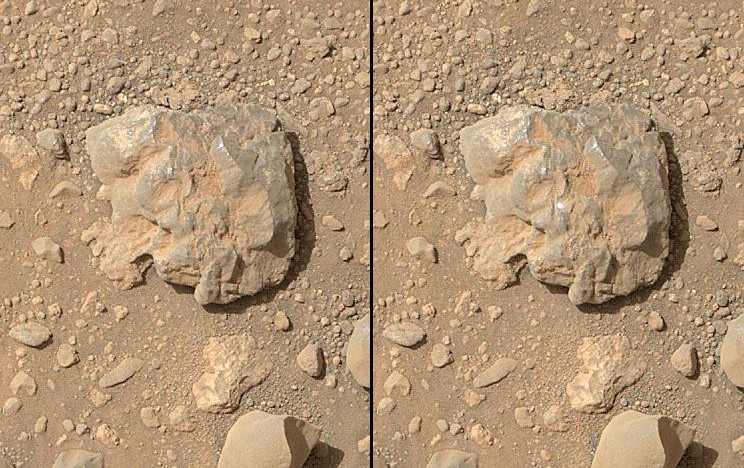
In the course of investigating the surface of Mars, NASA has uncovered some rather interesting and curious rock formations. And if once in awhile those rocks should resemble something odd and Earth-like then one should expect the media maelstrom that follows. And the sudden appearance of what people referred to as the “jelly doughnut” rock in January was no exception to this rule.
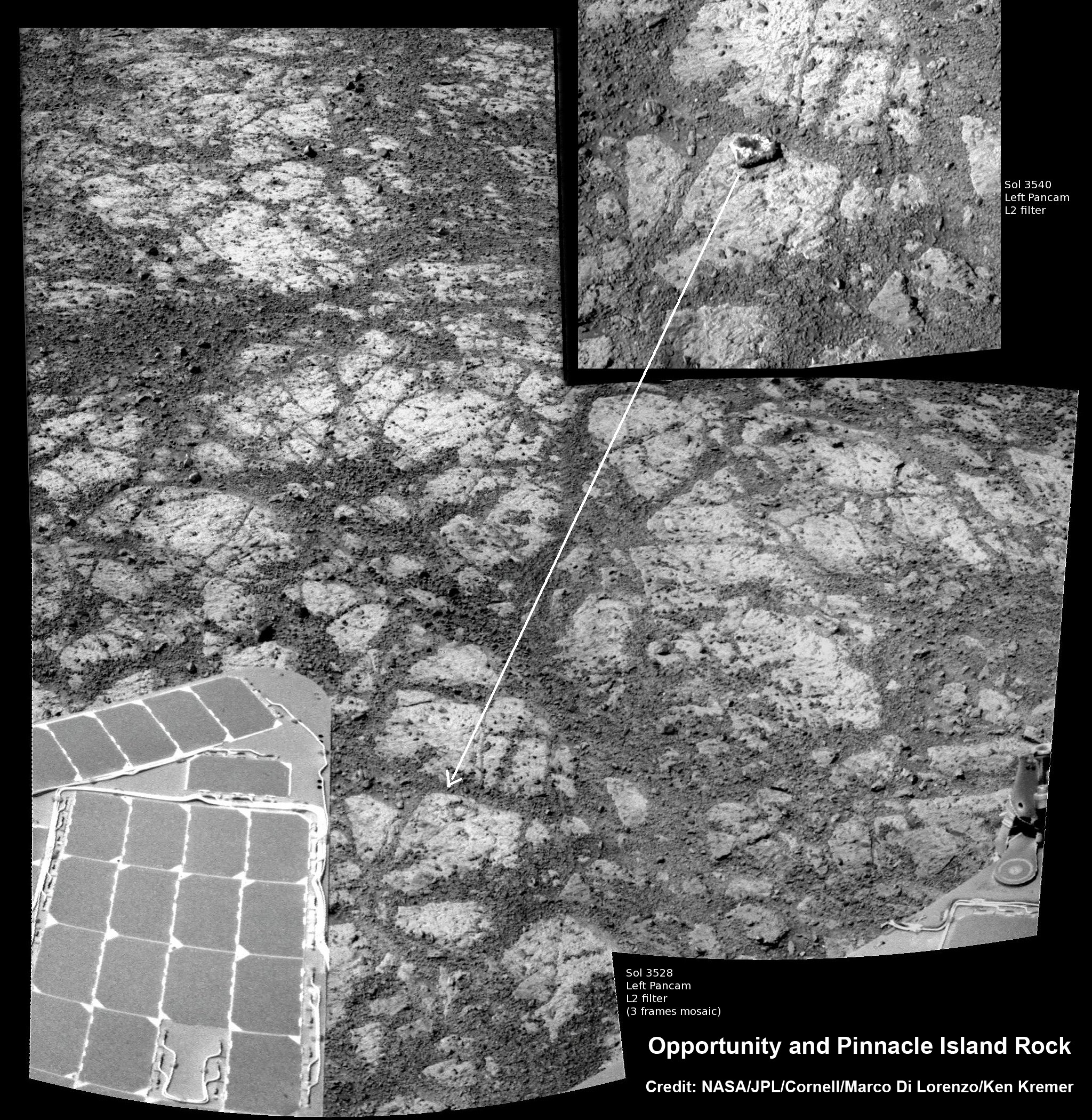
Much the Martian “rat” discovered last summer, the appearance of the doughnut rock was met with all kinds of speculation. The rock – now dubbed “Pinnacle Island” – first appeared on January 8th in a series of pictures taken by the Opportunity Rover. Measuring only about 4 centimeters (1.5 inches) in diameter with a noticeable white rim and red center, the rock quickly picked up the nickname “jelly doughnut”.
According to pictures taken just four days earlier by Opportunity, during which time it had not moved an inch, that area had been free of debris. In response, wild theories began to emerge, with some thinking it was an indication that rocks were falling from the sky. Others, looking to explain how something so odd in appearance could suddenly have appeared, claimed it was a heretofore undetected Martian surface beings.
Luckily, the ongoing work of mission scientists solved the by determining that the rock was actually created by an “alien invader” – the Opportunity Rover! Apparently, the mysterious rock was created when Opportunity unknowingly drove over a larger rock formation on Solander Point, where she is currently located. It then crushed the rock, sending fragments across the summit.
One piece, the ‘Pinnacle Island’ fragment, unwittingly rolled downhill where Opportunity caught it on camera a few days later. This explanation became apparent when the Opportunity was moved a tiny stretch and took some look-back photographs. Another fragment of the rock that was eerily similar in appearance to the ‘Pinnacle Island’ doughnut appeared, indicating that it had left a trail of such debris in its wake.
Ray Arvidson, Opportunity’s Deputy Principal Investigator, explained in a recent NASA statement:
Once we moved Opportunity a short distance, after inspecting Pinnacle Island, we could see directly uphill an overturned rock that has the same unusual appearance. We drove over it. We can see the track. That’s where Pinnacle Island came from.
To gather some up-close clues before driving away, the rover deployed its robotic arm to investigate ‘Pinnacle Island’ with her microscopic imager and APXS mineral mapping spectrometer. According to Arvidson, the results revealed high levels of the elements manganese and sulfur which suggest that:
[these] water-soluble ingredients were concentrated in the rock by the action of water. This may have happened just beneath the surface relatively recently, or it may have happened deeper below ground longer ago and then, by serendipity, erosion stripped away material above it and made it accessible to our wheels.
The Solander Point mountaintop is riven with outcrops of minerals, including clay minerals, that likely formed in flowing liquid neutral water conducive to life – a potential scientific goldmine. Thus, the presence of such water-soluble minerals in this particular rock indicates quite strongly that the Opportunity brought it with her while rolling through the area.
Meanwhile, on the opposite side of Mars, Opportunity’s younger sister rover Curiosity is trekking towards gigantic Mount Sharp and just crested over the Dingo Gap sand dune. She celebrated 500 days (Sols) on Mars on New Years Day, 2014. And a pair of new orbiters are streaking to the Red Planet to fortify Earth’s invasion fleet- NASA’s MAVEN and India’s MOM.
So expect more surprises from the Red Planet soon enough, which will include more information on surface conditions and the history of Mars’ atmosphere and how it disappeared. And maybe, just maybe, one of the rovers will uncover the existence of the long-sought after organic molecules – thus demonstrating unequivocally that life still exists on Mars.

 The rocky surface of Mars has turned up some rather interestingly-shaped objects in the past. First there was the Martian rat, followed shortly thereafter by the Martian donut; and very recently, the Martian thighbone. And in this latest case, the Curiosity rover has spotted what appears to be a perfectly-round ball. Even more interesting is the fact that this sphere may be yet another indication of Mars’ watery past.
 As Ian O’Neill of Discovery News, who spoke with NASA after the discovery, wrote:
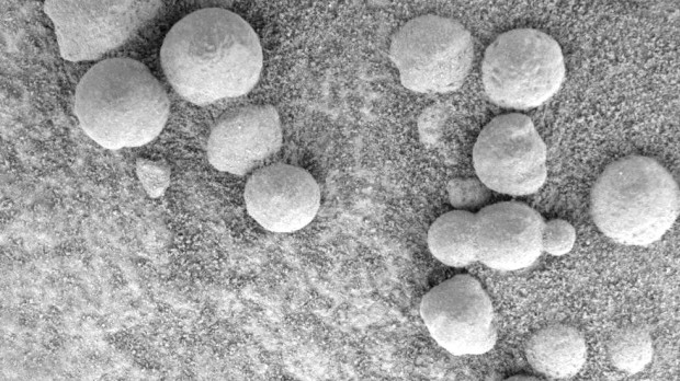 The spheres likely formed through a process called “concretion”, where minerals precipitate within sedimentary rock, often into oval or spherical shapes. When the rock erodes due to wind or water, it leaves the balls of minerals behind and exposed. If in fact concretion caused the Mars spheres, then they would be evidence there was once water on the planet. However, some scientists believe the rock balls might be leftover from meteorites that broke up in the Martian atmosphere.
 Mission managers will need to be careful as the rover has battered wheels from rougher terrain than expected. Because of this, the rover will slowly climb the slope of Mount Sharp driving backwards, so as to minimize the chance of any further damage. The Mars Reconnaissance Orbiter (MRO) will also be on hand to help, photographing the route from above to find the smoothest routes.
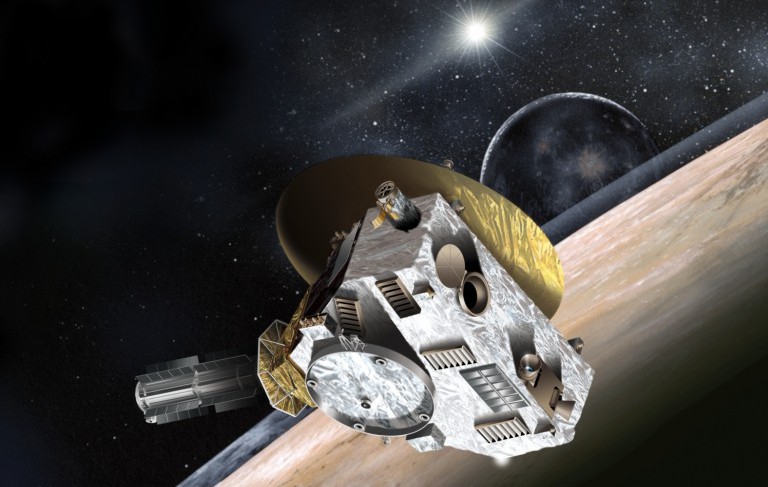


 The sedimentary layers in the lower slopes of Mount Sharp are the principal reason why the science team specifically chose Gale Crater as the primary landing site. Using high resolution spectral observations collected by NASA’s powerful Mars Reconnaissance Orbiter (MRO), they were able to determine the presence of deposits of clay-bearing minerals. or phyllosilicates, a key sign that organic molecules could exist on the planet.
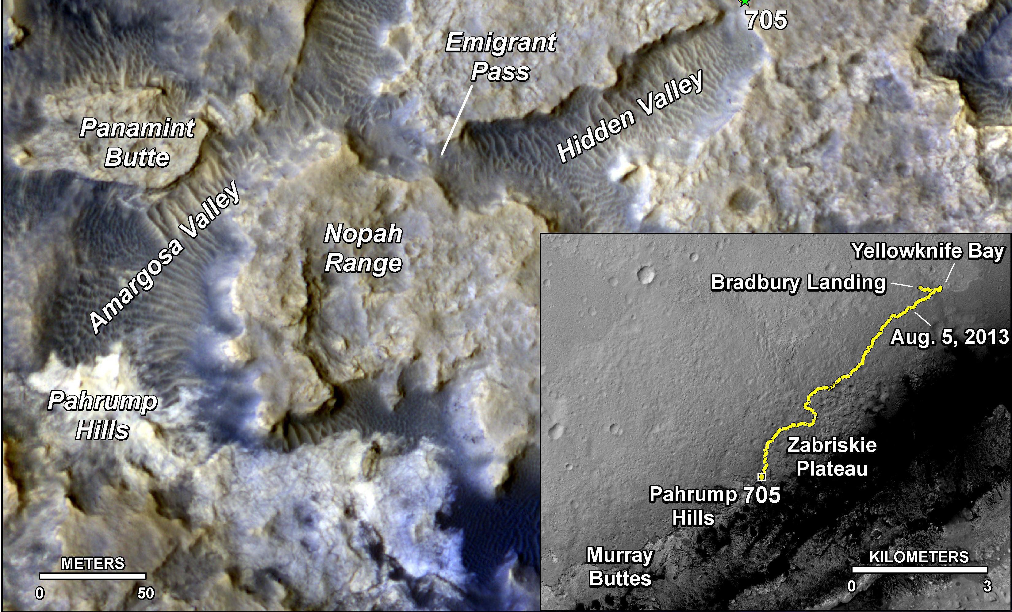


 Initial measurements at this site with the element-identifying alpha particle X-ray spectrometer at the end of Opportunity’s arm indicate that bright-toned veins in the rock contain calcium sulfate. Scientists deduce this mineral was deposited as water moved through fractures on Endeavour’s rim. The rover found similar veins of calcium sulfate farther north along the rim while investigating there earlier last month.


 As for the latest in Curiosity’s long-line of panoramic self-portraits, this one comes to us courtesy of Jason Major. As a graphic designer and amateur space explorer, Major assembled the picture from about the dozen or so images acquired with the rover’s Mars Hand Lens Imager (MAHLI) instrument on April 27-28, 2014 (Sol 613). In the background, one can see the 5.5-km-high (3.4 miles) Mount Sharp (Aeolis Mons) that sits in the center of the Gale Crater.