News from Mars: Mysterious Martian Ball Found!

Mars_ballThe rocky surface of Mars has turned up some rather interestingly-shaped objects in the past. First there was the Martian rat, followed shortly thereafter by the Martian donut; and very recently, the Martian thighbone. And in this latest case, the Curiosity rover has spotted what appears to be a perfectly-round ball. Even more interesting is the fact that this sphere may be yet another indication of Mars’ watery past.

The rock ball was photographed on Sept. 11 – on Sol 746 of the rover’s mission on Mars – while Curiosity was exploring the Gale Crater. One of Curiosity’s cameras captured several images of the centimeter-wide ball as part of the stream of photographs was taking. The scientists working at the Mars Science Laboratory based at NASA’s Jet Propulsion Laboratory (JPL), immediately began to examine it for indications of what it could be.

mars-selfie-01-140501As Ian O’Neill of Discovery News, who spoke with NASA after the discovery, wrote:

According to MSL scientists based at NASA’s Jet Propulsion Laboratory (JPL) in Pasadena, Calif., the ball isn’t as big as it looks — it’s approximately one centimeter wide. Their explanation is that it is most likely something known as a “concretion”… and they were created during sedimentary rock formation when Mars was abundant in liquid water many millions of years ago.

Curiosity has already found evidence of water at a dig site in Yellowknife Bay, which took place shortly after it landed in the Gale Crater two years ago. In addition, this is not the first time a Mars rover has found rocky spheres while examining the surface. In 2004, NASA’s Opportunity rover photographed a group of tiny balls made of a ferrous mineral called hematite. Opportunity photographed still more spheres, of a different composition, eight years later.

mars-blueberries
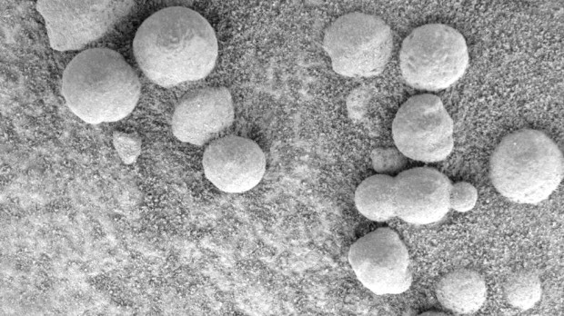
The spheres likely formed through a process called “concretion”, where minerals precipitate within sedimentary rock, often into oval or spherical shapes. When the rock erodes due to wind or water, it leaves the balls of minerals behind and exposed. If in fact concretion caused the Mars spheres, then they would be evidence there was once water on the planet. However, some scientists believe the rock balls might be leftover from meteorites that broke up in the Martian atmosphere.

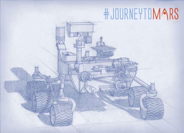
Curiosity is now at the base of Mount Sharp (Aeolis Mons) – The 5.6 km-high (3.5 mile) mountain in the center of Gale Crater – scientists are excited to commence the rover’s main science goal. This will consists of more drilling into layered rock and examining the powder so scientist can gain an idea about how habitable the Red Planet was throughout its ancient history, and whether or not it may have been able to support microbial life.

MarsCuriosityTrek_20140911_AMission managers will need to be careful as the rover has battered wheels from rougher terrain than expected. Because of this, the rover will slowly climb the slope of Mount Sharp driving backwards, so as to minimize the chance of any further damage. The Mars Reconnaissance Orbiter (MRO) will also be on hand to help, photographing the route from above to find the smoothest routes.

Despite the wear and tear that the little rover has experienced in its two years on the Martian surface, it has discovered some amazing things and NASA scientists anticipate that it will accomplish much more in the course of its operational history. And as it carried on with its mission to decode the secrets of Mars, we can expect it will find lots more interesting rocks – spherical, rat-shaped, ringed, femur-like, or otherwise.


Sources: cbc.ca, universetoday.com, news.discovery.com

The Future of Space: Building A Space Elevator!

space_elevator2Regularly scheduled trips to the Moon are one of many things science fiction promised us by the 21st century that did not immediately materialize. However, ideas are on the drawing board for making it happen in the coming decades. They include regular rocket trips, like those suggested by Golden Spike, but others have more ambitious plans. For example, there’s LiftPort – a company that hopes to build a space elevator straight to the Moon.

When he was working with NASA’s Institute for Advanced Concepts in the early 2000s, LiftPort President Michael Laine began exploring the idea of a mechanism that could get people and cargo to space while remaining tethered to Earth. And he is certainly not alone in exploring the potential, considering the potential cost-cutting measures it offers. The concept is pretty straightforward and well-explored within the realm of science fiction, at least in theory.

space_elevatorThe space elevator concept is similar to swinging a ball on a string, except it involves a tether anchored to the Earth that’s about 500 km long. The other end is in anchored in orbit, attached to a space station that keeps the tether taut. Anything that needs to be launched into space can simply be fired up the tether by a series of rocket-powered cars, which then dock with the station and then launched aboard a space-faring vessel.

Compared to using rockets to send everything into space, the cost using the elevator is far less (minus the one-time astronomical construction fee). And while the materials do not yet exist to construct 0ne, suggestions have been floated for a Lunar Elevator. Taking advantage of the Moon’s lower gravity, and using the Earth’s gravity well to stabilize the orbital anchor, this type of elevator could be built using existing materials.

space_elevator_lunar1One such person is Laine, who believes the capability exists to build an elevator that would reach from to the Moon to a distance of 238,000 km towards the Earth. Hence why, started two and a half years ago, he struck out to try and bring this idea to reality. The concept behind the Moon Elevator is still consistent with the ball on the string analogy, but it is a little more complicated because of the Moon’s slow orbit around the Earth.

The solution lies in Lagrangian points, which are places of gravitational equilibrium between two bodies. It’s here that the gravitational pull of both bodies are equal, and so they cancel each other out. Lagrangian point L1 is about 55,000 kilometers from the Moon, and that’s the one Laine hopes to take advantage of. After anchoring one end of the “string” on the Moon’s surface, it will extend to L1, then from L1 towards Earth.

lunar_space_elevatorAt the end of the string will be a counterweight made up of all the spent pieces of rocket that launched the initial mission to get the spike into the Moon. The counterweight will be in the right place for the Earth to pull on it gravitationally, but it will be anchored, through the Lagrange point, to the Moon. The force on both halves of the “string” will keep it taut. And that taut string will be a space elevator to the Moon.

What’s more, Laine claims that the Moon elevator can be built off-the-shelf, with readily available technology. A prototype could be built and deployed within a decade for as little as $800 million, he claims. It would be a small version exerting just a few pounds of force on the anchor on the Moon, but it would lay the groundwork for larger follow-up systems that could transport more cargo and eventually astronauts.

liftportTo demonstrate their concept, LiftPort is working on a proof-of-concept demonstration that will see a robot climb the tallest free­standing human structure in existence. This will consist of three large helium balloons held together on a tripod and a giant spool of Vectran fiber that is just an eighth of an inch think, but will be able to support 635 kilograms (1,400 pounds) and withstand strong winds.

Vectran is the same material was used by NASA to create the airbags that allowed the Spirit and Opportunity’s rovers to land on Mars. Since it gets stronger as it gets colder, it is ideal for this high altitude test, which will be LiftPort’s 15th experiment and the 20th robot to attempt an ascent. Laine doesn’t have a prospective date for when this test will happen, but insists it will take place once the company is ready.

LiftPort1Regardless, when the test is conducted, it will be the subject of a new documentary by Ben Harrison. Having learned about Liftport back in 2012 when he stumbled across their Kickstarter campaign, Harrison donated to the project and did a brief film segment about it for Engadget. Since that time, he has been filming Liftport’s ongoing story as part of a proposed documentary.

Much like Laine, Harrison and his team are looking for public support via Kickstarter so they can finish the documentary, which is entitled “Shoot the Moon”. Check out their Kickstarter page if feel like contributing. As of the time of writing, they have managed to raise a total of $14,343 of their $37,000 goal. And be sure to check out the promotional videos for the Liftport Group and Harrison’s documentary below:

Lunar Space Elevator Infrastructure Overview:


Shoot the Moon – Teaser Trailer:


Sources:
 motherboard.vice.com
, lunarelevator.com

News from Space: MOM Arrives!

MOM_orbiterHistory was made this week as India’s Mars Orbiter Mission successfully fired its braking rockets and arrived in Mars’ orbit. The arrival of India’s maiden interplanetary voyager was confirmed at 7:30am, India Standard Time (02:00 UTC, or 8:00pm EDT in the U.S. on Tuesday, Sept 23rd). MOM is the nation’s first attempt to explore the Red Planet, and represents a new era is space exploration.

By putting a probe in orbit around Earth’s neighbor, India has officially joined the elite club of only three other entities who have launched probes that successfully investigated Mars – i.e. Russia, the United States, and the European Space Agency (ESA). It also represents an expansion in the space exploration, a competition once confined to two superpowers, to five major participants – the US, Russia, ESA, India and China.

India_Mars_Orbiter1It took over ten months for MOM to cross the roughly 225 million kilometers (140 million miles) of interplanetary space that lie between Earth and Mars. Nevertheless, the 12.5 minutes that it took for the signal to reach Earth were far more intense and exciting. And the good news, which arrived at 10:30pm EDT (Sept. 23rd) or 8:00 IST (Sept. 24th) was met with wild applause and beaming smiles at India’s Bangalore mission control center.

MOM’s Red Planet arrival was webcast live worldwide by the Indian Space Research Organization (ISRO), India’s space agency which designed and developed the orbiter. ISRO’s website also gave a play by play in real time, announcing the results of critical spacecraft actions along the arrival timeline just moments after they became known. Indian PM Narenda Modi was watching the events unfold at ISRO’s Telemetry, Tracking and Command Network (ISTRAC).

MOM_arrivalUpon the announced arrival, Modi addressed the team, the nation and a global audience, lauding the accomplishment and outlining the benefits and importance of India’s space program. In a speech that echoes John F. Kennedy’s own from 50 years ago, Modi also implored the team to strive for even greater space exploration challenges:

India has successfully reached Mars! History has been created today. We have dared to reach out into the unknown and have achieved the near-impossible. I congratulate all ISRO scientists as well as all my fellow Indians on this historic occasion… We have gone beyond the boundaries of human enterprise and imagination. We have accurately navigated our spacecraft through a route known to very few. And we have done it from a distance so large that it took even a command signal from Earth to reach it more than it takes sunlight to reach us.

MOM’s success follows closely on the heels of NASA’s MAVEN orbiter which also successfully achieved orbit barely two days earlier on Sept. 21. Together, they will assess the extent to which Mars’ atmosphere decayed over the course of billions of years, and hopefully be able to reconstruct what it once looked like, and how it came to deteriorate. From all this, scientists hope to learn whether or not Mars once hosted life, and still is in some form.

maven_tv_backdropMOM now joins Earth’s newly fortified armada of seven spacecraft currently operating on Mars surface or in orbit – which includes MAVEN, Mars Odyssey (MO), Mars Reconnaissance Orbiter (MRO), Mars Express (MEX), Curiosity and Opportunity. Bruce Jakosky, MAVEN Principal Investigator, related well-wished on behalf of NASA in a post on the ISRO MOM Facebook page:

Congratulations to the MOM team on behalf of the entire MAVEN team! Here’s to exciting science from the two latest missions to join the Mars fleet!

MOM was launched on Nov. 5, 2013 from India’s spaceport at the Satish Dhawan Space Centre, Sriharikota, atop the nations indigenous four stage Polar Satellite Launch Vehicle (PSLV). The flight path of the approximately $73 Million probe was being continuously monitored by the Indian Deep Space Network (IDSN) and NASA JPL’s Deep Space Network (DSN) to maintain its course.

MOM_trajectoryThe do-or-die breaking maneuver that put MOM into orbit, known as the Mars Orbital Insertion (MOI), involved the craft’s engines firing for 24 minutes and 13 seconds. The entire maneuver took place autonomously under the spacecrafts preprogrammed sole control due to the long communications lag time and also during a partial communications blackout when the probe was traveling behind Mars and the signal was blocked.

As the ISRO said in a statement:

The events related to Mars Orbit Insertion progressed satisfactorily and the spacecraft performance was normal. The Spacecraft is now circling Mars in an orbit whose nearest point to Mars (periapsis) is at 421.7 km and farthest point (apoapsis) at 76,993.6 km. The inclination of orbit with respect to the equatorial plane of Mars is 150 degree, as intended. In this orbit, the spacecraft takes 72 hours 51 minutes 51 seconds to go round the Mars once.

MOM_pathMOM is expected to investigate the Red Planet for at least six months. Although it’s main objective is a demonstration of technological capabilities, it will also study the planet’s atmosphere and surface using five indigenous instruments – including a tri color imager (MCC) and a methane gas sniffer (MSM). Methane on Earth originates from both geological and biological sources – and could be a potential marker for the existence of Martian microbes.

Both MAVEN and MOM’s goal is to study the Martian atmosphere , unlock the mysteries of its current atmosphere and determine how, why and when the atmosphere and liquid water was lost – and how this transformed Mars climate into its cold, desiccated state of today. This will shed light not only on whether or not Mars supported life in the past, but if it still does in some form, and could possibly do so again.

This is an exciting time for space exploration, when ground-breaking news is happening on a regular basis and promises to lead to potentially Earth-shattering news in the future! And in the meantime, be sure to check out this video that recap’s MOM’s historic mission and arrival, courtesy of WorldBreakingNews:


And this animation of the MAVEN and MOM orbit:


Sources:
universetoday.com, (2), nasaspaceflight.com

News from Space: NASA Showcases New Rover Tools

NASA_2020rover1Last Thursday at the agency’s headquarters in Washington, NASA unveiled more information about its Mars 2020 rover, which is scheduled to join Opportunity and Curiosity on the Red Planet by the end of the decade. The subject of this latest press release was the rover’s payload, which will consist of seven carefully-selected instruments that will conduct unprecedented science and exploratory investigations, and cost about $130 million to develop.

These instruments were selected from 58 proposals that were submitted back in January by researchers and engineers from all around the world. This is twice the usual number of proposals that NASA has received during instrument competitions in the recent past, and is a strong indicator of the extraordinary level of interest the scientific community is taking in the exploration of the Mars.

NASA_2020roverThese seven new instruments include:

  • Mars Oxygen ISRU Experiment (MOXIE): this technology package will process the Martian atmosphere into oxygen. ISRU stands for In Situ Resource Utilization.
  • Planetary Instrument for X-ray Lithochemistry (PIXL): this spectrometer will use a high-resolution imager and X-ray fluorescence for detailed elemental analysis to a finer degree than possible with any prior equipment.
  • Scanning Habitable Environments with Raman & Luminescence for Organics and Chemicals (SHERLOC): this sensor suite will use an ultraviolet laser for fine-scale mineralogy, detecting organic compounds, and high-resolution imaging.
  • Mastcam-Z: an advanced camera system that will send home panoramic and stereoscopic images and assist with rover operations and help determine surface mineralogy.
  • SuperCam: an imaging device with super capacities to perform chemical composition analysis and more mineralogy. This tool will allow the rover to peer around hunting for organic compounds within rocks or weathered soils from a distance, helping identify interesting locations to sample in greater detail.
  • Mars Environmental Dynamics Analyzer (MEDA): This sensor suite to measure temperature, wind speed and direction, pressure, and relative humidity. As dust is such a defining characteristic of weather on the red planet, it’s also going to measure dust size and shape, helping characterize how big of a hassle it will make housekeeping.
  • Radar Imager for Mars’ Subsurface Exploration (RIMFAX): a ground-penetrating radar to imagine the subsurface to centimeter-scale resolution.

These instruments will be used to determine how future human explorers could exploit natural resources to live on Mars, pinning down limits to how much we could rely on using local materials. In addition, demonstration technology will test out processing atmospheric carbon dioxide to produce oxygen, a key step towards using local resources for manufacturing oxidizers for rocket fuel and suitable for humans.

NASA_2020rover5This is perhaps the most exciting aspect of the proposed mission, which is looking ahead to the possibility of manned Martian exploration and even settlement. To quote William Gerstenmaier, the associate administrator for the Human Exploration and Operations Mission Directorate at NASA Headquarters in Washington:

Mars has resources needed to help sustain life, which can reduce the amount of supplies that human missions will need to carry. Better understanding the Martian dust and weather will be valuable data for planning human Mars missions. Testing ways to extract these resources and understand the environment will help make the pioneering of Mars feasible.

At the same time, and in keeping with plans for a manned mission, it will carry on in NASA’s long-term goal of unlocking Mars’ past and determining if life ever existed there. As John Grunsfeld, astronaut and associate administrator of NASA’s Science Mission Directorate in Washington, explained:

The Mars 2020 rover, with these new advanced scientific instruments, including those from our international partners, holds the promise to unlock more mysteries of Mars’ past as revealed in the geological record. This mission will further our search for life in the universe and also offer opportunities to advance new capabilities in exploration technology.

Mars_footprintNASA addressed these goals and more two weeks ago with their mission to Mars panel at the 2014 Comic-Con. This event, which featured retired astronaut and living legend Buzz Aldrin, spoke at length to a packed room about how Apollo 11 represented the “the first Giant Leap”. According to Aldrin, the Next Giant Leap could be “Apollo 45 landing humans on Mars.”

The panel discussion also included enthusiastic support of Orion and the Space Launch System which are currently under development and will be used when it finally comes time to send human explorers to join the rovers on Mars. The Mars 2020 mission will be based on the design of the highly successful Mars Science Laboratory rover, Curiosity, which landed almost two years ago.

NASA_2020rover2Not only does it look virtually identical to Curiosity – from its six-wheeled chassis, on-board laboratory, and instrument-studded retractable arms – and will even be partly built using Curiosity’s spare parts.It will also land on Mars using the same lowered-to-the-surface-by-a-giant-sky-crane method. NASA als0 plans to use the rover to identify and select a collection of rock and soil samples that will be stored for potential return to Earth by a future mission.

These rock samples will likely have to wait until the proposed manned mission of 2030 to be picked up, but NASA seems hopeful that such a mission is in the cards. In the meantime, NASA is waiting for their MAVEN orbiter to reach Mars and begin exploring it’s atmosphere (it is expected to arrive by September), while the InSight Lander – which will examine Mars’ interior geology – is slated for launch by March 2016.

terraformingSo we can expect a lot more news and revelations about the Red Planet in the coming months and years. Who knows? Maybe we may finally find evidence of organic molecules or microbial life there soon, a find which will prove once and for all that life exists on other planets within our Solar System. And if we’re really lucky, we might just find that it could feasibly support life once again…

Sources: cbc.ca, fastcompany.com, nasa.gov, space.io9.com, (2), extremetech.com

News from Mars: Opportunity Still at Work

opportunityAfter ten years in service (when it wasn’t supposed to last longer than nine months), one would think that left for the Opportunity rover to do. And yet, Opportunity is still hard at work, thanks in no small part to its solar panels being their cleanest in years. In its latest research stint, NASA’s decade-old Mars Exploration Rover Opportunity is inspecting a section of crater-rim ridgeline chosen as a priority target due to evidence of a water-related mineral.

Orbital observations of the site by another NASA spacecraft – the Mars Reconnaissance Orbiter (MRO) – found a spectrum with the signature of aluminum bound to oxygen and hydrogen. Researchers regard that signature as a marker for a mineral called montmorillonite, which is in a class of clay minerals (called smectites) that forms when basalt is altered under wet and slightly acidic conditions. The exposure of it extends about 240 meters (800 feet) north to south on the western rim of Endeavour Crater.

Mars_Reconnaissance_OrbiterThe detection was made possible using the MRO’s Compact Reconnaissance Imaging Spectrometer for Mars (CRISM) combined with rover observations some 3 kms (2 miles) north on the crater’s western rim. Rocks exposed there contain evidence for an iron-bearing smectite – called nontronite – as well as for montmorillonite. That site yielded evidence for an ancient environment with water that would have been well-suited for use by microbes, evidence that could boost our understanding of what Mars looked like billions of years ago.

Opportunity reached the northern end of the montmorillonite-bearing exposure last month – a high point known as “Pillinger Point.” Opportunity’s international science team chose that informal name in honor of Colin Pillinger (1943-2014), the British principal investigator for the Beagle 2 project, which attempted to set a research lander on Mars a few weeks before Opportunity landed there in January of 2004.

Beagle 2Opportunity Principal Investigator Steve Squyres, of Cornell University, had this to say about Pillinger:

Colin and his team were trying to get to Mars at the same time that we were, and in some ways they faced even greater challenges than we did. Our team has always had enormous respect for the energy and enthusiasm with which Colin Pillinger undertook the Beagle 2 mission. He will be missed.

Though selected as a science destination, Pillinger Point also offers a scenic vista from atop the western rim of Endeavour Crater, which is about 22 kms (14 miles) in diameter. The picture below shows a section of a color shot taken by Opportunity’s panoramic camera (Pancam) upon arrival. A full-size view of this picture can be seen by going to NASA’s Jet Propulsion Laboratory Mars Exploration Rovers webpage.

Pillinger_pointInitial measurements at this site with the element-identifying alpha particle X-ray spectrometer at the end of Opportunity’s arm indicate that bright-toned veins in the rock contain calcium sulfate. Scientists deduce this mineral was deposited as water moved through fractures on Endeavour’s rim. The rover found similar veins of calcium sulfate farther north along the rim while investigating there earlier last month.

As Opportunity investigated this site and other sites farther south along the rim, the rover had more energy than usual. This was due to the solar cells being in rare form, says Opportunity Project Manager John Callas of NASA’s Jet Propulsion Laboratory:

The solar panels have not been this clean since the first year of the mission. It’s amazing, when you consider that accumulation of dust on the solar panels was originally expected to cause the end of the mission in less than a year. Now it’s as if we’d been a ship out at sea for 10 years and just picked up new provisions at a port of call, topping off our supplies.

Both Opportunity and its rover twin, Spirit, benefited from sporadic dust-cleaning events in past years. However, on the ridge that Opportunity has been navigating since late 2013, winds have removed dust more steadily, day by day, than either rover has experienced elsewhere. The rover’s signs of aging – including a stiff shoulder joint and occasional losses of data – have not grown more troublesome in the past year, and no new symptoms have appeared.

mountsharp_galecraterJPL’s Jennifer Herman, power-subsystem engineer added:

It’s easy to forget that Opportunity is in the middle of a Martian winter right now. Because of the clean solar arrays, clear skies and favorable tilt, there is more energy for operations now than there was any time during the previous three Martian summers. Opportunity is now able to pull scientific all-nighters for three nights in a row — something she hasn’t had the energy to do in years.

During Opportunity’s first decade on Mars and the 2004-2010 career of Spirit, NASA’s Mars Exploration Rover Project yielded a range of findings about wet environmental conditions on ancient Mars – some very acidic, others milder and more conducive to supporting life. These findings have since been supplemented and confirmed by findings by the Curiosity Rover, which hopes to find plenty of clues as to the nature of possible life on Mars when it reaches Mount Sharp later this summer.

Source: sciencedaily.com, marsrovers.jpl.nasa.gov

News from Space: Insight Lander and the LDSD

mars-insight-lander-labelledScientists have been staring at the surface of Mars for decades through high-powered telescopes. Only recently, and with the help of robotic missions, has anyone been able to look deeper. And with the success of the Spirit, Opportunity and Curiosity rovers, NASA is preparing to go deeper. The space agency just got official approval to begin construction of the InSight lander, which will be launched in spring 2016. While there, it’s going to explore the subsurface of Mars to see what’s down there.

Officially, the lander is known as the Interior Exploration Using Seismic Investigations, Geodesy and Heat Transport, and back in May, NASA passed the crucial mission final design review. The next step is to line up manufacturers and equipment partners to build the probe and get it to Mars on time. As with many deep space launches, the timing is incredibly important – if not launched at the right point in Earth’s orbit, the trip to Mars would be far too long.

Phoenix_landingUnlike the Curiosity rover, which landed on the Red Planet by way of a fascinating rocket-powered sky crane, the InSight will be a stationary probe more akin to the Phoenix lander. That probe was deployed to search the surface for signs of microbial life on Mars by collecting and analyzing soil samples. InSight, however, will not rely on a tiny shovel like Phoenix (pictured above) – it will have a fully articulating robotic arm equipped with burrowing instruments.

Also unlike its rover predecessors, once InSight sets down near the Martian equator, it will stay there for its entire two year mission – and possibly longer if it can hack it. That’s a much longer official mission duration than the Phoenix lander was designed for, meaning it’s going to need to endure some harsh conditions. This, in conjunction with InSight’s solar power system, made the equatorial region a preferable landing zone.

mars-core_bigFor the sake of its mission, the InSight lander will use a sensitive subsurface instrument called the Seismic Experiment for Interior Structure (SEIS). This device will track ground motion transmitted through the interior of the planet caused by so-called “marsquakes” and distant meteor impacts. A separate heat flow analysis package will measure the heat radiating from the planet’s interior. From all of this, scientists hope to be able to shed some light on Mars early history and formation.

For instance, Earth’s larger size has kept its core hot and spinning for billions of years, which provides us with a protective magnetic field. By contrast, Mars cooled very quickly, so NASA scientists believe more data on the formation and early life of rocky planets will be preserved. The lander will also connect to NASA’s Deep Space Network antennas on Earth to precisely track the position of Mars over time. A slight wobbling could indicate the red planet still has a small molten core.

If all goes to plan, InSight should arrive on Mars just six months after its launch in Spring 2016. Hopefully it will not only teach us about Mars’ past, but our own as well.

LDSDAfter the daring new type of landing that was performed with the Curiosity rover, NASA went back to the drawing table to come up with something even better. Their solution: the “Low-Density Supersonic Decelerator”, a saucer-shaped vehicle consisting of an inflating buffer that goes around the ship’s heat shield. It is hopes that this will help future spacecrafts to put on the brakes as they enter Mar’s atmosphere so they can make a soft, controlled landing.

Back in January and again in April, NASA’s Jet Propulsion Laboratory tested the LDSD using a rocket sled. Earlier this month, the next phase was to take place, in the form of a high-altitude balloon that would take it to an altitude of over 36,600 meters (120,000 feet). Once there, the device was to be dropped from the balloon sideways until it reached a velocity of four times the speed of sound. Then the LDSD would inflate, and the teams on the ground would asses how it behaved.

LDSD_testUnfortunately, the test did not take place, as NASA lost its reserved time at the range in Hawaii where it was slated to go down. As Mark Adler, the Low Density Supersonic Decelerator (LDSD) project manager, explained:

There were six total opportunities to test the vehicle, and the delay of all six opportunities was caused by weather. We needed the mid-level winds between 15,000 and 60,000 feet [4,500 meters to 18,230 meters] to take the balloon away from the island. While there were a few days that were very close, none of the days had the proper wind conditions.

In short, bad weather foiled any potential opportunity to conduct the test before their time ran out. And while officials don’t know when they will get another chance to book time at the U.S. Navy’s Pacific Missile Range in Kauai, Hawaii, they’re hoping to start the testing near the end of June. NASA emphasized that the bad weather was quite unexpected, as the team had spent two years looking at wind conditions worldwide and determined Kauai was the best spot for testing their concept over the ocean.

If the technology works, NASA says it will be useful for landing heavier spacecraft on the Red Planet. This is one of the challenges the agency must surmount if it launches human missions to the planet, which would require more equipment and living supplies than any of the rover or lander missions mounted so far. And if everything checks out, the testing goes as scheduled and the funding is available, NASA plans to use an LDSD on a spacecraft as early as 2018.

And in the meantime, check out this concept video of the LDSD, courtesy of NASA’s Jet Propulsion Laboratory:


Sources:
universetoday.com, (2), extremetech.com

New Technique Reveals Angkor Wat’s Hidden Art

Angkor_WatEvery year, millions of visitors flock to Angkor Wat – an ancient temple in modern-day Cambodia and the heart of the one-time capitol of the Khmer Empire. There, they marvel at the 900-year-old towers, a giant moat and the shallow relief sculptures of Hindu gods, and the intricate architecture and carvings. However, until very recently, they were unaware of the paintings on the temple walls, representations of daily life that were hiding in plain sight.

Built between A.D. 1113 and 1150, Angkor Wat stood at the center of Angkor, the capital of the Khmer Empire. The 500-acre (200 hectares) complex, one of the largest religious monuments ever erected, originally served as a Hindu temple dedicated to the god Vishnu, but was transformed into a Buddhist temple in the 14th century. Since that time, the temple has become a symbol of national pride for Cambodia and the source of much archaeological and historical research and speculation.

Angkor-Wat-1Thanks to digitally enhanced images, some tw0-hundred detailed murals have bee revealed that depict elephants, deities, boats, orchestral ensembles and people riding horses — all of which were invisible to the naked eye. According to the researchers who uncovered it, many of the faded markings could be graffiti left behind by pilgrims after Angkor Wat was abandoned in the 15th century. However, the more elaborate paintings may be relics of the earliest attempts to restore the temple.

The paintings were first noticed by  Noel Hidalgo Tan, a rock-art researcher of the Australian National University in Canberra, while he was working on an excavation at Angkor Wat in 2010. After first spotting the red and black pigment on the walls of the monument, he decided to investigate further. After scientists took pictures using an intense flash, they then used a tool from NASA to digitally enhance the colors of the images.

NW Corner Facing STo make these paintings visible, Tan and his associates used a technique called Decorrelation Stretch Analysis, which exaggerates subtle color differences. This method has become a valuable tool in rock-art research, as it can help distinguish faint images from the underlying rock. It has even been used to enhance images taken of the Martian surface by NASA’s Opportunity rover when conducting surface studies and geological analysis.

According to Antiquity, a quarterly archeology review, what they found was 200 depictions of ancient life. These included paintings of elephants, lions, the Hindu monkey god Hanuman, boats and buildings — perhaps even images of Angkor Wat itself. Tan went back to the site to conduct a more methodical survey in 2012 with his Cambodian colleagues from APSARA (Authority for the Protection and Management of Angkor and the Region of Siem Reap).

Some of the most detailed paintings, the ones located at the top of the temple, are passed by literally thousands of visitors every day, but the most elaborate scenes are effectively invisible to the naked eye.

SW Corner facing EOne chamber in the highest tier of Angkor Wat’s central tower, known as the Bakan, contains an elaborate scene of a traditional Khmer musical ensemble known as the pinpeat, which is made up of different gongs, xylophones, wind instruments and other percussion instruments. In the same chamber, there’s an intricate scene featuring people riding horses between two structures, which might be temples. As Tan explained:

A lot of the visible paintings on the walls have been previously discounted as graffiti, and I certainly agree with this interpretation, but there are another set of paintings discovered from this study that are so schematic and elaborate that they are likely not random graffiti, but an attempt to decorate the walls of the temple.

Christophe Pottier, an archaeologist and co-director of the Greater Angkor Project who was not involved in the new study, agreed that these more complex murals show deliberate intention and can’t be interpreted as mere graffiti. Pottier, however, added that the discovery of hidden paintings isn’t all that surprising. Though they haven’t been studied systematically before now, several traces of paintings have been found at the temple during the last 15 years.

Facing SAnd though researchers can’t be sure exactly when the paintings were created, Tan speculates that the most elaborate artworks may have been commissioned by Cambodia’s King Ang Chan, who made an effort to restore the temple during his reign between 1528 and 1566. During this time, unfinished carvings were completed and Angkor Wat began its transformation into a Buddhist pilgrimage site, which are confirmed by some of the newly revealed paintings that show Buddhist iconography.

Ultimately, getting an accurate look at ancient heritage sites and representations is only one of the benefits of this new process. In addition, there is the potential for heritage conservation. With countless sites around the world being threatened by war, environmental issues, and neglect, getting a digital record of pictures like these will ensure that the works of ancient peoples to chronicle their lives and express themselves artistically will be preserved, long after the physical objects are gone.

Sources: scientificamerican.com, time.com

News From Space: Curiosity’s Latest Photos

curiosity_sol-177-1April was a busy month for the very photo-talented (and photogenic) Curiosity Rover. In addition to another panoramic shot of the Martian landscape – which included Curiosity looking back at itself, making it a “selfie” – the rover also managed to capture a night-sky image that captured two minor planets and the Martian moon of Deimos in the same picture. At a time when Curiosity and Opportunity are both busy on long-haul missions to find evidence of life, these latest pictures remind us that day-to-day operations on Mars are still relevant.

The first shot took place on April 20th (Sol 606), when rover scientists used the Mast Camera to capture the minor planets of Ceres and Vesta, as well as the moon of Deimos, in the same frame. Ceres is a minor planet with a diameter of about 950 km, and is the largest object in the main asteroid belt. With a diameter of about 563 km, Vesta is the third-largest object in the asteroid belt. Deimos, meanwhile, is the smaller of Mars’ two moons, with a mean radius of 6 km.

curiosity_nightskyIn the main portion of the new image (seen above), Vesta, Ceres and three stars appear as short streaks due to the duration of a 12-second exposure. In other camera pointings the same night, the Curiosity’s camera also imaged Phobos and the planets Jupiter and Saturn, which are shown as insets on the left.  Dr Mark Lemmon from Texas A&M University, a Curiosity team member, explained:

this imaging was part of an experiment checking the opacity of the atmosphere at night in Curiosity’s location on Mars, where water-ice clouds and hazes develop during this season… The two Martian moons were the main targets that night, but we chose a time when one of the moons was near Ceres and Vesta in the sky.

Deimos was much brighter than the visible stars, Vesta and Ceres in the same part of the sky, in the main image. The circular inset covers a patch of sky the size that Earth’s full moon appears to observers on Earth. At the center of that circular inset, Deimos appears at its correct location in the sky, in a 0.25 second exposure.

Curiosity_selfie
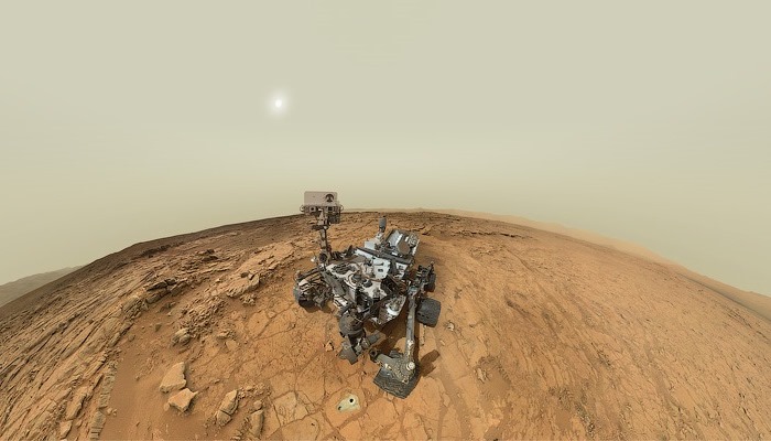
As for the latest in Curiosity’s long-line of panoramic self-portraits, this one comes to us courtesy of Jason Major. As a graphic designer and amateur space explorer, Major assembled the picture from about the dozen or so images acquired with the rover’s Mars Hand Lens Imager (MAHLI) instrument on April 27-28, 2014 (Sol 613). In the background, one can see the 5.5-km-high (3.4 miles) Mount Sharp (Aeolis Mons) that sits in the center of the Gale Crater.

One thing that Major noted about the picture he assembled is the way the cylindrical RUHF antenna and the bit of the RTG that is visible in the lower center seem to form a “toothy (if slightly dusty) grin”. But, as he stated:

…with almost 21 Earth-months on Mars and lots of discoveries already under her robot belt, Curiosity (and her team) certainly have plenty to smile about!

And the best is likely to still be coming. As we speak, Curiosity is making its way towards Mount Sharp and is expected to arrive there sometime in August. As the primary goal in its mission, Curiosity set off for this destination back in June after spending months studying Glenelg area. She is expected to arrive at the foot of the mountain in August, where she will begin drilling in an effort to study the mountain’s vast caches of minerals – which could potentially support a habitable environment.

mountsharp_galecraterIf Curiosity does find evidence of organic molecules in this cache, it will be one of the greatest scientific finds ever made, comparable only to the discovery of hominid remains in the Olduvai Gorge, or the first recorded discovery of dinosaur remains. For not only will we have definitive proof that life once existed on Mars, we will know with some certainly that it may again someday…

Stay tuned for more news from the Red Planet. And in the meantime, keep on trucking Curiosity!

Sources: sci-news.com, universetoday.com

News From Mars: Jelly Donut Rock Mystery Solved

mars_donut1In the course of investigating the surface of Mars, NASA has uncovered some rather interesting and curious rock formations. And if once in awhile those rocks should resemble something odd and Earth-like then one should expect the media maelstrom that follows. And the sudden appearance of what people referred to as the “jelly doughnut” rock in January was no exception to this rule.

Much the Martian “rat” discovered last summer, the appearance of the doughnut rock was met with all kinds of speculation. The rock – now dubbed “Pinnacle Island” – first appeared on January 8th in a series of pictures taken by the Opportunity Rover. Measuring only about 4 centimeters (1.5 inches) in diameter with a noticeable white rim and red center, the rock quickly picked up the nickname “jelly doughnut”.

mars_donutAccording to pictures taken just four days earlier by Opportunity, during which time it had not moved an inch, that area had been free of debris. In response, wild theories began to emerge, with some thinking it was an indication that rocks were falling from the sky. Others, looking to explain how something so odd in appearance could suddenly have appeared, claimed it was a heretofore undetected Martian surface beings.

Luckily, the ongoing work of mission scientists solved the by determining that the rock was actually created by an “alien invader” – the Opportunity Rover! Apparently, the mysterious rock was created when Opportunity unknowingly drove over a larger rock formation on Solander Point, where she is currently located. It then crushed the rock, sending fragments across the summit.

Opportunity-Route-map_Sol-3560_Ken-KremerOne piece, the ‘Pinnacle Island’ fragment, unwittingly rolled downhill where Opportunity caught it on camera a few days later. This explanation became apparent when the Opportunity was moved a tiny stretch and took some look-back photographs. Another fragment of the rock that was eerily similar in appearance to the ‘Pinnacle Island’ doughnut appeared, indicating that it had left a trail of such debris in its wake.

Ray Arvidson, Opportunity’s Deputy Principal Investigator, explained in a recent NASA statement:

Once we moved Opportunity a short distance, after inspecting Pinnacle Island, we could see directly uphill an overturned rock that has the same unusual appearance. We drove over it. We can see the track. That’s where Pinnacle Island came from.

Opportunity-and-Pinnacle-Island_Sol-3540_1_Ken-KremerTo gather some up-close clues before driving away, the rover deployed its robotic arm to investigate ‘Pinnacle Island’ with her microscopic imager and APXS mineral mapping spectrometer. According to Arvidson, the results revealed high levels of the elements manganese and sulfur which suggest that:

[these] water-soluble ingredients were concentrated in the rock by the action of water. This may have happened just beneath the surface relatively recently, or it may have happened deeper below ground longer ago and then, by serendipity, erosion stripped away material above it and made it accessible to our wheels.

The Solander Point mountaintop is riven with outcrops of minerals, including clay minerals, that likely formed in flowing liquid neutral water conducive to life – a potential scientific goldmine. Thus, the presence of such water-soluble minerals in this particular rock indicates quite strongly that the Opportunity brought it with her while rolling through the area.

mars-map

Meanwhile, on the opposite side of Mars, Opportunity’s younger sister rover Curiosity is trekking towards gigantic Mount Sharp and just crested over the Dingo Gap sand dune. She celebrated 500 days (Sols) on Mars on New Years Day, 2014. And a pair of new orbiters are streaking to the Red Planet to fortify Earth’s invasion fleet- NASA’s MAVEN and India’s MOM.

So expect more surprises from the Red Planet soon enough, which will include more information on surface conditions and the history of Mars’ atmosphere and how it disappeared. And maybe, just maybe, one of the rovers will uncover the existence of the long-sought after organic molecules – thus demonstrating unequivocally that life still exists on Mars.

Stay tuned!


Source: universetoday.com

Life on Mars: What it Once Looked Like

mars_oxygenBillions of years ago when the Red Planet was young, it appears to have had a thick atmosphere that was warm enough to support oceans of liquid water, and perhaps even life. Thanks to past and ongoing research conducted by the Spirit, Opportunity and Curiosity rovers, NASA scientists are certain that Mars once boasted conditions that would have supported life.

To dramatize these discoveries, NASA’s Goddard Space Flight Center has created a video representation of what the environment might have looked like billions of years ago. The artist’s concept opens with Mars appearing as a warm, wet place, and then transitioning to the climate that we know today.  As the atmosphere gradually disappears, it changes from the Earthlike blue to the dusty pink and tan hues of Mars today.

As the description reads on NASA Goddard’s Youtube page:

The animation shows how the surface of Mars might have appeared during this ancient clement period, beginning with a flyover of a Martian lake. The artist’s concept is based on evidence that Mars was once very different. Rapidly moving clouds suggest the passage of time, and the shift from a warm and wet to a cold and dry climate is shown as the animation progresses.

By the end, Mars has transformed to the acrid environment of 2013 – all “dusty pink and tan hues”. One day, NASA believes it may be possible to bring the environment back from this fate. Though its a mere theory at this point, terraforming could transform Mars back into a warm, wet, and life-sustaining planet once more. Enjoy the clip!


Source: fastcoexist, svs.gsfc.nasa.gov