In the course of the past century, science fiction has provided us with many interesting visions of what the future of transportation will look like. And whereas not long ago, many of these seemed like hopeless fantasy – such as the failure of flying cars or robotic automated vehicles to become a reality by 2000 – recent years and developments have seen reality slowly catching up.
Case in point, last year, the European company named “2GetThere” installed a small fleet of automated podcars (aka. robotaxis) in the eco-friendly community of Masdar City. Similarly, the town of San Jose began work on the Personal Rapid Transit System – a series of on-call, point to point transit cars designed to replace the town’s system of taxis and buses, providing an environmentally friendly alternative to traditional mass transit.
And most recently, the town of Milton Keynes – a sleepy city north of London – that is planning on conducting a podcar system trial run by 2015. Similar to the system at Heathrow Airport, which uses 21 on-call podcars on a 4 km (2.5 mile) stretch of track, the system will consist of a series of pods that will be able to carry two passengers, plus baggage, from the town’s train station to its downtown offices and the shopping district.
Milton Keynes’ plans is much more ambitious, calling for a fleet of 100 vehicles that will travel with far ore independently, albeit in a designated lane with curbs. The trial will assess safety and how people (and animals) react to them. The pods travel at up to 19 km/h (12 mph) and will contain GPS, cameras, and sensors to ensure they don’t crash into anything.
And if all goes well, the system will be adopted by 2017 and residents will pay little more than a bus fare ($3.20) to travel in automated luxury. Purpose-built in the 1960s, Milton Keynes has an unusual grid layout that makes it an ideal testing ground for a plan that other British cities are seriously considering. Given the dual issues of congestion and pollution in British cities, a system of robotaxis seems like the perfect solution.
In fact, such a solution is ideal when it comes to all major cities around the world. The state of robotics, automation, centralized grids, and the reduced impact electrical transit has compared to gasoline-powered cars and buses, we could be looking at a world where every major city has its own system of robotaxis in the near future.
And I imagine a massive grid of Hyperoops lines will be connecting every major city… The future is likely to be mighty cool! In the meantime, enjoy this video of Heathrow’s podcar system in action:
Well, it’s finally finished. After months of being behind on getting Whiskey Delta‘s sequel ready for publication, I am finally finished with my edits. And now, I turn it over to my betas and those who’ve selflessly volunteered to take this book on with me. I sincerely hope I got all the typos and errors out in that first run.
Probably not, but it’s nice to think that the next round of edits will be mercifully brief so I can get this book out before the holidays. Fans of the first book specifically requested a sequel, and people shouldn’t have to wait for a year to get one. You hear that George RR Martin?
Another reason I need to get this book out is because of my progress on the third, or rather lack thereof. Twice now I’ve tried to get the ball rolling on that story, only to find myself backtracking a few weeks later and deleting everything I wrote.
I know why too, I can feel in my heart that I’m overreaching. Until such time as I can get book II out and get some feedback on the story, I know I won’t feel confident plotting out the third one. I imagine there are plenty of people out there who know what I’m talking about 😉
In any case, look for it soon. Papa Zulu, second book in the Whiskey Delta series!
It had has been a big month in the field of space probes and satellites. Whether they are in orbit around Mercury, on their way to Mars, or floating in the outer Solar System, there’s been no shortage of news and inspirational footage to be had. And it is a testament to the age we live in, where space news is accessible and can instantly be shared with millions of people around the world.
First up, there’s the recent release of Cassini’s magnificent image of Saturn’s rings shining in all their glory. Back in July, Cassini got a good look back at Earth from about 1.5 billion kilometers (932 million miles) away. Known as “The Day The Earth Smiled”, NASA has spent the past few months cobbling together this picture from numerous shots taken during Cassini’s circuitous orbit around Saturn.
Cassini has always been able to take impressive pictures in Earth’s general direction, but this picture was special since it used the enormous bulk of Saturn to block the usually confounding brightness of the Sun. Cassini, which was launched to survey the outer planets in 1997, captured an absolutely incredible image of both the Earth as a pale blue dot, and of Saturn as a striking, luminous apparition.
As part of NASA’s latest awareness campaign, which tried to get everyday citizens to smile at the sky for the first posed interplanetary photo most of us have ever experienced, the photo captured the halo effect that makes our sixth planet look truly breathtaking. In the annotated version (pictured above), you can also see Venus, Mars, and some of Saturn’s moons.
Next up, there’s the MESSENGER probe, which managed to capture these impressive new videos of Mercury’s surface. As part of the NASA Advisory Council (NAC) ride-along imaging campaign, these videos were captured using the Mercury Dual Imaging System (MDIS). Even though the original high-res images were captured four seconds apart, these videos have been sped up to a rate of 15 images per second.
The views in each video are around 144-178 km (90-110 miles) across. The large crater visible in the beginning of the second video is the 191-km (118-mile) wide Schubert basin. In related news, there are new maps of Mercury available on the US Geological Survey website! Thanks to MESSENGER we now have the entirety of the first planet from the Sun imaged and mapped.
MESSENGER launched from Cape Canaveral Air Force Station back in August of 2004 and established orbit around Mercury on March 18th, 2011. It was the first man-made spacecraft ever to do so, and has provided the most comprehensive mapping of Mercury to date, not to mention evidence of ice, organic molecules, and detailed conditions on the surface.
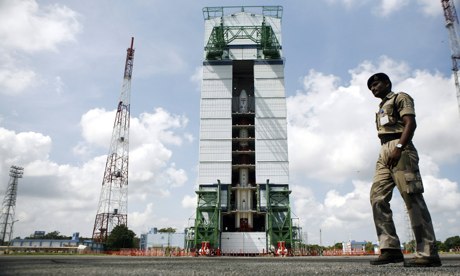
And last, but not least, there was the recent launch of the Indian Space Research Organization’s (ISRO) new Mars Orbiter Mission (aka. MOM). The launch took place on Tuesday, November 5th from the Indian space port located on a small island in the Bay of Bengal. As the nation’s first attempt to reach the Red Planet, the aim of the $70 million mission goes beyond mere research.
In addition to gathering information that might indicate if life has ever existed or could exist on Mars, the mission is also meant to showcase India’s growing prowess in the field of space and to jump ahead of its regional rival (China) in the big interplanetary march. As Pallava Bagla, one of India’s best known science commentators, put it:
In the last century the space race meant the US against the Soviets. In the 21st century it means India against China. There is a lot of national pride involved in this.
In addition, there has been quite a bit of speculation that the missionw as designed to stimulate national pride in the midst of an ongoing economic crisis. In recent years, a plunging currency, ailing economy and the state’s seeming inability to deliver basic services have led many Indians to question whether their nation is quite as close to becoming a global superpower as it seemed in the last decade.
MOM is expected to arrive in the vicinity of Mars on September 24th, 2014 where it will assume an elliptical orbit around the planet and begin conducting atmospheric surveys. If all continues to goes well, India will the elite club of only four nations that have launched probes which successfully investigated the Red Planet from orbit or the surface – following the Soviet Union, the United States and the European Space Agency (ESA).
MOM was also the first of two new Mars orbiter science probes that left Earth and began heading for Mars this November. The second was NASA’s $671 million MAVEN orbiter, which launched on November 18th atop an Atlas V rocket from Cape Canaveral in Florida. MAVEN is slated to arrive just two days before MOM, and research efforts will be coordinated between the two agencies.
Much like MAVEN, MOM’s goal is to study the Martian atmosphere , unlock the mysteries of its current state and determine how, why and when the atmosphere and liquid water were lost – and how this transformed Mars climate into its cold, desiccated state it is in today. In addition to aiding our scientific understanding of the world, it may help us to transform the planet into a liveable environment once again.
For many people, these developments are an indication of things to come. If humanity ever intends to become an interplanetary species, an expanding knowledge of our Solar System is an absolute prerequisite. And in many respects, making other planets our home may be the only way we can survive as a species, given our current rate of population growth and consumption.
For enthusiasts of 3-D printing and its many possibilities, a man like Berokh Khoshnevis needs no introduction. As for the rest of us, he is the USC’s Director of Manufacturing Engineering, and has spent the last decade working on a new direction for this emerging technology. Back in 2012, he gave a lecture at TEDxTalks where he proposed that automated printing and custom software could revolutionize construction as we know it.
Intrinsic to this vision are a number of technologies that have emerged in recent years. These include Computer-Assisted Design/Computer-Assisted Manufacturing (CAD/CAM), robotics, and “contour crafting” (i.e. automated construction). By combining design software with a large, crane-sized 3-D printing machine, Khoshnevis proposes a process where homes can be built in just 20 hours.
Khoshnevis started working on the idea when he realized the gigantic opportunity in introducing more speed and affordability into construction. All of the technology was already in place, all that was required was to custom make the hardware and software to carry it all out. Since that time, he and his staff have worked tirelessly to perfect the process and vary up the materials used.
Working through USC’s Center for Rapid Automated Fabrication Technologies, Khoshnevis and his students have made major progress with their designs and prototypes. His robotic construction system has now printed entire six-foot tall sections of homes in his lab, using concrete, gypsum, wood chips, and epoxy, to create layered walls sections of floor.
The system uses robotic arms and extrusion nozzles that are controlled by a computerized gantry system which moves a nozzle back and forth. Cement, or other desired materials, are placed down layer by layer to form different sections of the structure. Though the range of applications are currently limited to things like emergency and temporary shelters, Khoshnevis thinks it will someday be able to build a 2,500-square-foot home in 20 hours.
As he describes the process:
It’s the last frontier of automation. Everything else is made by machines except buildings. Your shoes, your car, your appliances. You don’t have to buy anything that is made by hand.
As Khoshnevis explained during his 2012 lecture at TEDx, the greatest intended market for this technology is housing construction in the developing world. In such places of the world, this low-cost method of creating housing could lead to the elimination of slums as well as all the unhealthy conditions and socioeconomic baggage that comes with them.
But in the developed world, he also envisions how contour crafting machines could allow homes to be built more cheaply by reducing labor and material costs. As he pointed out in his lecture, construction is one of the most inefficient, dirty and dangerous industries there is, more so than even mining and oil drilling. Given a method that wastes far less material and uses less energy, this would reduce our impact on the natural environment.
But of course, what would this all be without some serious, science fiction-like applications? For some time now, NASA and the ESA has been looking at additive manufacturing and robotics to create extra-terrestrial settlement. Looking farther afield, NASA has given Khoshnevis a grant to work on building lunar structures on the moon or other planets that humans could one day colonize.
According to NASA’s website, the construction project would involve:
Elements suggested to be built and tested include landing pads and aprons, roads, blast walls and shade walls, thermal and micrometeorite protection shields and dust-free platforms as well as other structures and objects utilizing the well known in-situ-resource utilization (ISRU) strategy.
Many existing technologies would also be employed, such as the Lunar Electric Rover, the unpressurized Chariot rover, the versatile light-weight crane and Tri-Athlete cargo transporter as well some new concepts that are currently in testing. These include some habitat mockups and new generations of spacesuits that are currently undergoing tests at NASA’s Desert Research And Technological Studies (D-RATS).
Many of the details of this arrangement are shrouded in secrecy, but I think I can imagine what would be involved. Basically, the current research and development paradigm is focusing on combining additive manufacturing and sintering technology, using microwaves to turn powder into molten material, which then hardens as it is printed out.
To give you an idea of what they would look like, picture a crane-like robot taking in Moon regolith or Martian dust, bombarding it with microwaves to create a hot glue-like material, and then printing it out, layer by layer, to create contoured modules as hard as ceramic. These modules, once complete, would be pressurized and have multiple sections – for research, storage, recreation, and whatever else the colonists plan on getting up to.
Pretty cool huh? Extra-terrestrial colonies, and a cheaper, safer, and more environmentally friendly construction industry here on Earth. Not a bad way to step into the future! And in the meantime, be sure to enjoy this video of contour crafting at work, courtesy of USC’s Center for Rapid Automated Fabrication Technologies:
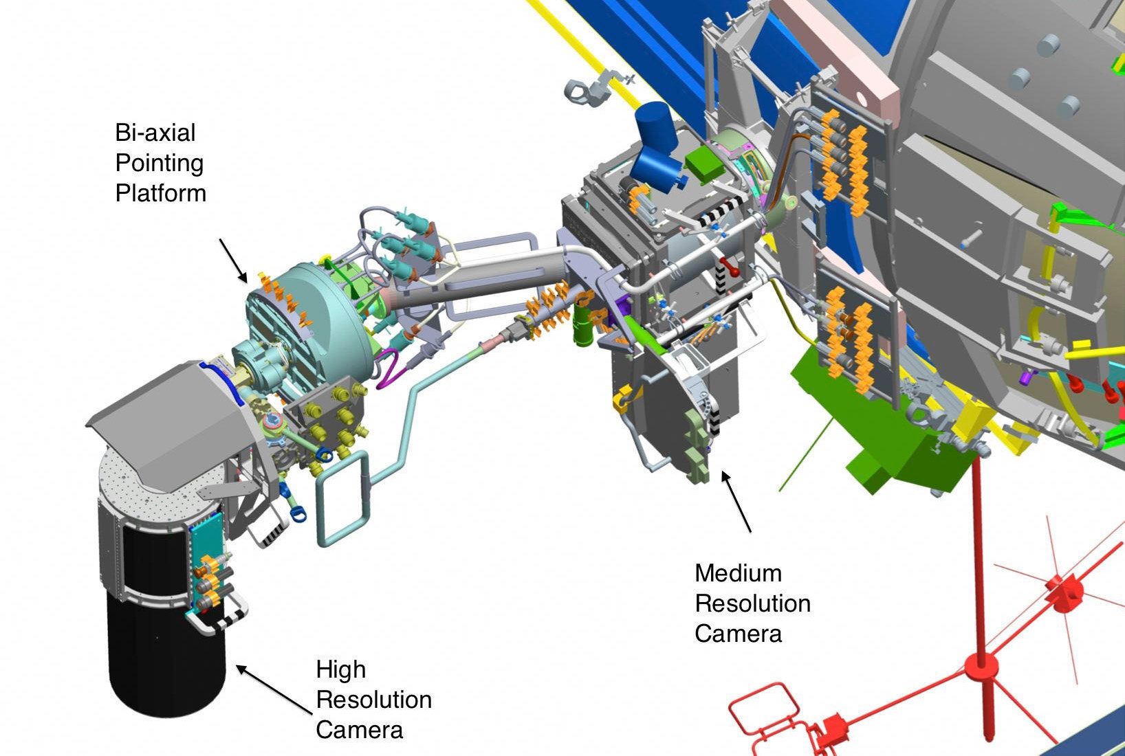
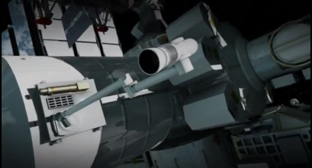
Two High-Definition cameras designed to stream detailed views of Earth from the International Space Station blasted off into space yesterday. The cameras are the work of UrtheCast, a Vancouver-based company that distributes operational software for publicly accessibly HD cameras and broadcasts. Once installed, they will provide a view of Earth that is usually reserved for astronauts.
The cameras – one still and one video camera – launched at 3:52 p.m. ET from the Baikonur Cosmodrome in Kazahkstan on an unmanned Russian Progress spacecraft aboard a Soyuz rocket. The two cameras will be attached to a platform on the underside of the space station that was brought up by a previous Progress flight in July and installed by Russian cosmonauts during a spacewalk.
The cameras will be able to view a large band of the Earth between the latitudes of 51 degrees north and 51 degrees south, covering everything from the Canadian Prairies and the southern tip of Chile and Argentina. What’s more, their resolution will be high enough that people will be able to see things as small as cars, boats, their own homes, and even small groups of people.
The company stressed though that individual people would not be discernible as the resolution is simply not high enough to make out facial features. The fixed, still camera will take a continuous video panorama of Earth 50 kilometres wide as the space station orbits Earth 16 times each day. Meanwhile, the other camera will be pointable and able to be directed at specific points on the globe.
And while many of the images they take will be available free online just a few hours after they were captured, customers will also have access to specific footage captured by the second, pointed camera. So for a small fee, people will be able to take part in what the company likes to call the “world’s first near-live HD video feed of Earth.”
The company expects customers to include governments, non-governmental organizations and corporations that would like particular types of live and archival images for purposes such as monitoring the environment. As Chris Carter, director of wealth management for ScotiaMcLeod and CBC Radio’s Vancouver business columnist, claims that this expectation is valid since UrtheCast’s business model allows it avoid a major hurdle.
Basically, the greatest impediment to providing space-based footage of the Earth is the astronomical (no pun!) cost of getting cameras into space. UrtheCast has gotten around this hurdle by partnering with Roscosmos, the Russian Space Agency, who transported their cameras in exchange for free access to images that it might otherwise have to pay for.
According to a statement made by the company earlier this month, as of Sept. 30, the company – which trades on the Toronto Stock Exchange – had annual purchase commitments worth $21 million:
Although these purchase commitments cannot be considered binding prior to the cameras being installed on the ISS, UrtheCast has already begun the process of converting these purchase commitments into binding commercial agreements.
The democratic space age is looming, people. Between regular updates on social media and webcasts from NASA rovers and space satellites, to live feeds from publicly-accessible cameras, we are entering an age where exploration and research are accessible like never before. Add to this the dream of telexploration, and we could be looking at a future where astronauts do NOT get to have all the fun!
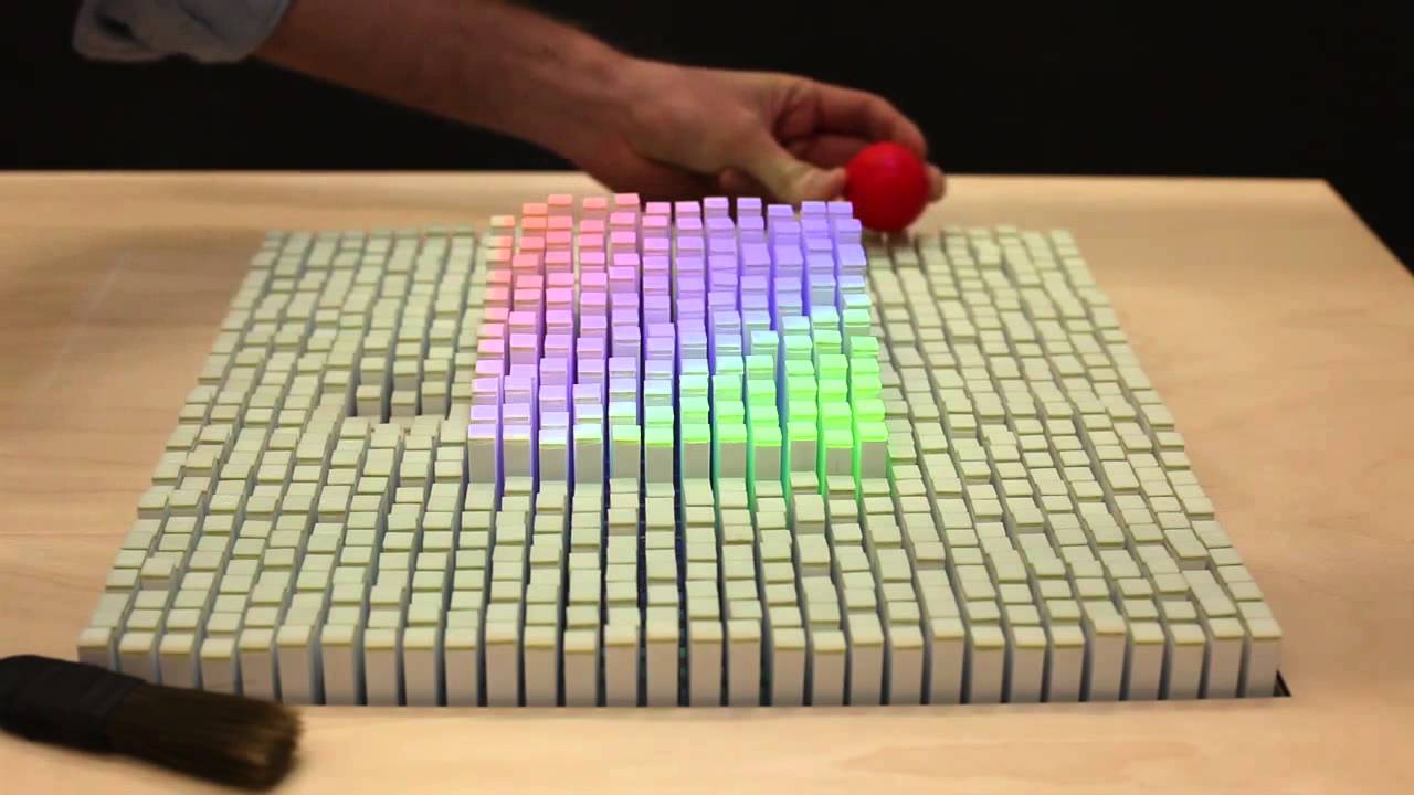
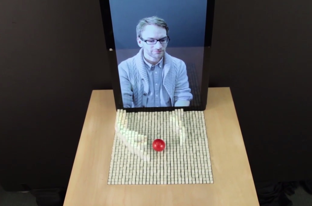
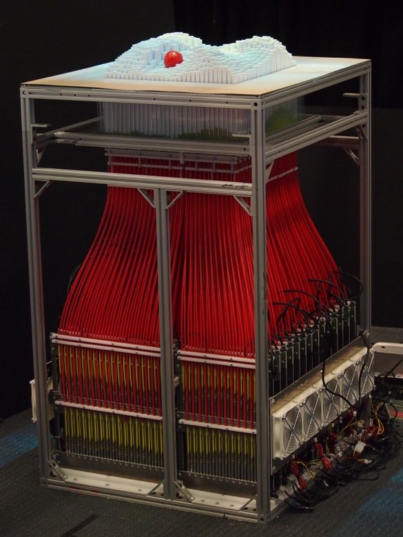
The future of computing is tactile. That’s the reasoning behind the inFORM interface, a revolutionary new interface produced by the MIT Media Lab and the Tangible Media Group. Unveiled earlier this month, the inFORM is basically a surface that changes shapes in three-dimensions, allowing users to not only interact with digital content, but even make simulated physical contact with other people.
Created by Daniel Leithinger and Sean Follmer and overseen by Professor Hiroshi Ishii, the technology behind the inFORM isn’t actually quite simple. Basically, it functions like a fancy Pinscreen, one of those executive desk toys that allows you to create a rough 3-D model of an object by simply pressing it into a bed of flattened pins.
However, with the inFORM, each of those “pins” is connected to a motor controlled by a nearby laptop. This not only moves the pins to render digital content physically, but can also register real-life objects interacting with its surface thanks to the sensors of a hacked Microsoft Kinect. In short, you can touch hands with someone via Skype, or feel a stretch of terrain through Google Maps.
Another possible application comes in the form of video conferencing, where remote participants can be displayed physically, allowing for a strong sense of presence and the ability to interact physically at a distance. However, Tangible Media Group sees the inFORM as merely a step along the long road towards what they refer to “Tangible Bits”, or a Tangible User Interface (TUI).
This concept is what the group sees as the physical embodiment of digital information & computation. This constitutes a move away from the current paradigm of “Painted Bits”, or Graphical User Interfaces (GUI), something that is based on intangible pixels that do not engage users fully. As TMG states on their website:
Humans have evolved a heightened ability to sense and manipulate the physical world, yet the GUI based on intangible pixels takes little advantage of this capacity. The TUI builds upon our dexterity by embodying digital information in physical space. TUIs expand the affordances of physical objects, surfaces, and spaces so they can support direct engagement with the digital world.
It also represents a step on the long road towards what TMG refers to as “Radical Atoms”. One of the main constraints with TUI’s, according to Professor Ishii and his associates, is their limited ability to change the form or properties of physical objects in real time. This constraint can make the physical state of TUIs inconsistent with the underlying digital models.
Radical Atoms, a vision which the group unveiled last year, looks to the far future where materials can change form and appearance dynamically, becoming as reconfigurable as pixels on a screen. By bidirectionally coupling this material with an underlying digital model, dynamic changes in digital states would be reflected in tangible matter in real time, and vice versa.
This futuristic paradigm is something that could be referred to as a “Material User Interface (MUI).” In all likelihood, it would involve polymers or biomaterials that are embedded with nanoscopic wires, that are able to change shape with the application of tiny amounts of current. Or, more boldy, materials that are composed of utility fogs or swarms of coordinated nanorobots that can alter their shape at will.
Certainly the ambitious concept, but as the inFORM demonstrates, its something that is getting closer. And the rate at which it is getting here is growing faster every day. And you have to admit, though the full-scale model does look a little bit like a loom, it does make for a pretty impressive show. And in the meantime, be sure to enjoy this video of the inFORM in action.
With the recent upsurge in school shootings – 43 in the last three years, resulting in 76 and 64 injuries – its little wonder why various school-based options at are being explored. These range from more guns (arming teachers and administrators) to incorporating special alarms that would allow for high-speed response. But perhaps the most creative (albeit odd) response comes in the form of a bulletproofing a classroom.
Specifically, armored whiteboards and bulletin boards (known as “Safeboards”) are being proposed as a last line of defense against gunmen. Developed by the International Armoring Corporation – a Utah-based company that manufactures lightweight armored passenger vehicles for heads of state, celebrities, and even the Pope – these boards are unobtrusive classroom objects that double as bulletproof barriers. In the event of a shooting, a teacher could manually slide and lock them in front of a door within a few seconds. Another version folds away from the wall to create a classroom safe haven that could fit up to 37 average-sized first graders. The Safeboards are capable of resisting the bullets of high-powered rifles, like those used in a number of school shootings in recent years.
The company began developing the product last year before the Sandy Hook shooting in Connecticut took place. After a few school officials near IAC’s headquarters heard about how the company manufacture lightweight armor for protective vehicles, they asked if there were any affordable products that could improve safety in the event of a school shooting.
Bulletproof doors already exist, but they expensive and are very heavy. This can be problematic since these doors still need to be used by children dozens of times a day. According to IAC’s CEO Mark Burton, the sliding Safeboard, made with the firm’s standard lightweight material, starts at $1,850 and is light enough that it can be open and closed even by children.
Though no purchases have been made yet, the risk management director of the David School District of Utah (home to some 70,000 students), a school architect and a police liaison witnessed a demonstration of the technology. The district has already upgraded its alarms and camera systems, but director Scott Zigich, indicated that additional measures are being weighed:
Just this week [the country] had a shooting at an airport, a shooting at a school, a shooting at a mall. We are very active in trying to increase the safety level of our students and employees due to the frequent nature of violent attacks.
The state of Utah and IAC are hardly alone on this issue. Earlier this year, another company in Maryland responded to the need for added security by developing small armored whiteboards that would act more like individual shields. Here, the company behind the design is Hardwire, whose product is already being featured at the Worcester Preparatory School in Berlin, Maryland.
Interestingly enough, these whiteboards use the same light material that is used by company to protect military vehicles from Improvised Explosive Devices (IEDs). In the wake of the Sandy Hook shooting, many schools have come to see the issue of gun violence in terms of guerrilla warfare, and are responding accordingly. According to Hardwire CEO George Tunis:
[The Whiteboards] basically take handguns out of the equation. We can certainly make them to stop any threat in the world, but what we wanted was something handheld for the teachers.
For some time, a debate has raged around the United States, especially in the wake of Sandy Hook shooting. At its core is the question of what constitutes appropriate defensive measures for schools in a society where guns are easy for almost anyone to obtain. And some schools have considered armed guards or even armed teachers.
However, people like Mark Burton believes guns as a defense weapon often do more harm than good in schools, and considers the Safeboard to be a less disruptive and cost-effective measure that could give a classroom under siege needed time until police arrive. For budget-strapped schools, the decision is a financial issue as well as a safety one.
Over the lifetime of the product, Burton claims a Safeboard would cost as little as $5 a student, and IAC will also offer a financing program. But ultimately, its about finding ways to deal with the issue that doesn’t involve escalation. As Burton explained:
This is whole new territory. It’s kind of a fine line to walk. It is a sensitive issue, but in some cases, I think it could save lives.
And in the end, one has to wonder, are armored classrooms the only recourse to arming teachers and administrators? Is the issue of gun control really so elusive and untouchable that Americans must choose between more armor or more weapons in schools? What does it take to protect our children without treating our classrooms like they are warzones?
Reducing the cost of space missions is one of the greatest challenges facing engineers and technicians today. With a myriad of planned missions, ranging from everything to a settlement on the Moon, sending satellites to Near-Earth asteroids, and manned missions to Mars, the goal of making space travel more affordable is a persistent and important one.
As it stands, most efforts are directed towards created craft that are either reusable, repurposed, or simply don’t rely on big, expensive and disposable rockets to get them into orbit. But another angle at bringing the cost of missions down is focusing on the size of the space craft themselves. If they could be shrunk down to the point where they are no larger than a paperweight, sending them into space could be done on the cheap.
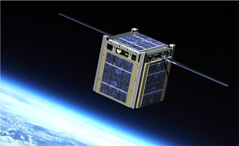
Already we are seeing this idea at work with CubeSats, a new breed of satellites that are roughly the size of a Rubik’s cube. Over the past decade, dozens of these satellites have been sent into space, often as part of University projects. Since most sensor and survey equipment is now small enough that it can fit into a shoebox, the CubeSat design is ideal for departments that cannot afford to mount multimillion dollar space missions.
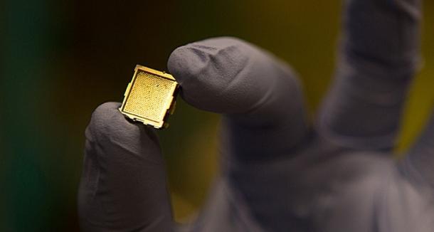
Expanding on this concept, MIT’s Poalo Lozano, a professor and the director of the Institute’s Space Propulsion Laboratory, has unveiled a new type of “microthruster” which, when added to the scaled-down satellites, could radically reduce the cost of space missions even further. Roughly the size of a stamp, these tiny ion-engines would prolong the use of satellites by ensuring they could maneuver in space.
Up until now, CubeSat’s have had a limited life expectancy as their orbits inevitably decay and they burn up in the Earth’s atmosphere. But by equipping them with an Electrospray Propulsion System (iEPS), these pint-sized satellites would be able to conduct life-saving maneuvers that would extend their period of service and give them new functionality.
The thrusters are basically a liquid-fuel system that, when a voltage is applied, emit a stream of ions through tiny nozzles that propel the satellite forward. According to Lozano, four of these thrusters could provide attitude control and main propulsion for standard solar-powered “1U” CubeSat, which measures about 10 centimeters (4 inches) on a side and weighs 1 kilogram (2.2 pounds).
But more exciting are the long-term prospects created by the addition of these tiny thrusters. For the price of sending a large spacecraft, a fleet of CubeSats could be dispatched to explore the moons of Jupiter. Other possible missions include clearing the massive pile of orbital debris floating around the Earth, de-orbiting satellites at the end of their service lives, and correcting atmospheric drag in low Earth orbit.
Part of what makes plans like these so feasible is the fuel-to-weight ratio it allows for spacecraft, something which astronauts and space agencies always have to take into account. As the Space Propulsion Laboratory claims on their website:
Less than 150 g of propellant would be required by a 1U CubeSat to reach Earth’s escape velocity from [low Earth orbit] and explore interplanetary space.
Other possibilities arise from the fact that iEPS units require very little in the way of fuel, so even scaled-up versions can be fitted to small satellites to provide cost-effective and fuel-efficient thrust. Scientists in Switzerland, for instance, say they can send a shoebox-size satellite to the moon in six months with only a few drops of fuel.
As Professor Lozano said, in regards to the long term plans for the iEPS concept:
The goal is to make [CubeSats] do most of the things we already do with big satellites, except in a less expensive way. People have very big plans for these very small spacecraft.
But in reality, even the outer Solar System is not limit when it comes to this scaled-down satellite technology. Looking even further abroad, tiny satellites could be sent into deep space to map out what lies between our Solar System and other stars, or investigate the mysteries of the Milky Way. Asteroid prospecting could also benefit from small, cost-effective probes that are capable of navigating between rocks.
And when the technology is scaled down even further, perhaps even to the nano level, millions of tiny probes could be sent out into space to study dark matter, high-energy particles, and seek out new life. Combined with new technologies like space penetrators, entire solar systems and even galaxies could be seeded with tiny space sats. Exciting possibilities indeed!
And in the meantime, be sure to check out this video on CubeSat’s, courtesy of Singularity HUB:
Earlier this month, the Super Typhoon Haiyan smashed into the island nation of the Philippines, leaving an enormous amount of death and destruction in its wake. According to NASA, the typhoon struck with winds that exceeded 379 kilometers per hour (235 mph), while the U.S. Navy Joint Typhoon Warning Center indicates that it has since sustained wind speeds of over 315 kilometers per hour (95 MPH).
Classified as a Category 5 monster storm on the U.S. Saffir-Simpson scale, Haiyan is reported to be the largest and most powerful storm ever to make landfall in recorded human history. The current estimates claim that some 5000 people have died so far, with the final toll expected to be far higher.
Given the enormous scale of this typhoon, many of the clearest pictures of it have come from space. Since it first made landfall on Friday, November 8th, many detailed images have been captured by NASA, the Russian Space Agency, the India’s newly-launched Mars Orbiter Mission (MOM), and even from the ISS – courtesy of astronaut Karen Nyberg.
According to NASA, the most detailed data on the storm came from the Tropical Rainfall Measuring Mission (TRMM) satellite, which captured visible, microwave and infrared data on the storm just as it was crossing the island of Leyte in the central Philippines. In addition to gauging wind speed, the satellite was also able to measure precipitation rates and temperature fluctuations.
Far from simply documenting this tragedy, the high resolution imagery and precise measurements provided by these and other satellites have been absolutely essential to tracking this storm and providing advance warning. Whereas thousands have died in the effected areas, some 800,000 more have been evacuated from the central region of the country.
Coincidentally, NASA’s Goddard Flight Center has just finished assembling the next generation weather satellite known as the Global Precipitation Measurement (GPM), an observatory that is scheduled to replace the Tropical Rainfall Measuring Mission. GPM is equipped with advanced, higher resolution radar instruments and is vital to the continued effort of providing forecasts and advance warning of extreme super storms.
In the midst of tragedies like Hurricane Sandy and Haiyan, not to mention the escalating risk of super-storms associated with Climate Change, it is good to know that there are silver linings, such as advanced warning and sophisticated instruments that can keep us apprised of the threats we face. For more information on Super Typhoon Haiyan and how you can aid in the recovery, check out the Internationa Red Cross’ website.
And be sure to check out this video of Haiyan as it made landfall, as captured by the Russian weather satellite Electro-L:
This past summer, Elon Musk once again impressed the world with his futuristic design for a high-speed transit tube that could take passengers from Los Angeles and San Francisco in just 30 minutes. It’s known as the Hyperloop, a “fifth form” of transportation that would utilize linear electric motors, solar panels, and air cushions to achieve speeds of up to 1290 kilometers per hour (800 mph).
Unfortunately, Musk also indicated that with his current, busy schedule, it would be many years before a working demonstration could be produced. What’s more, he was unclear on what role, if any, he would play in its creation. The project was unveiled as an open-source venture, and he called upon business investors to take up the role of making it happen.
However, some investors have come forward to do just that. Gathering around the entrepreneurial collaboration platform known as JumpStartFund, these enthusiasts have come together to create a corporation that will see Musk’s concept through to development. This is no small task, seeing as how the price-tag (according to Musk) would be between 6 and 10 billion dollars.
JumpStartFund launched on August 22, and aims to give entrepreneurs a network through which to both seek funding and support as well as crowdsource the idea and collaborate with others to refine it. The Hyperloop concept, put up on the site by the JumpStart team, became the platform’s flagship project within its first week of launch.
Dirk Ahlborn, CEO and co-founder of JumpStartFund, said in an interview back in September:
We want to be the ones that actually make things happen. So of course we need to create a corporation. Whoever decides to dedicate more time to this than just logging onto the platform deserves to be part of this company.
Because Ahlborn and his co-founders have connections with SpaceX, they were able to talk over the idea with the company’s president, Gwynne Shotwell, and get the green light to feature it on the platform. Joining them are engineers Marco Villa and Patricia Galloway, who worked for SpaceX and the US National Science Board respectively and even held directorial and vice chair positions.
JumpStartFund is also accepting applications from members of the site to work full-time on the Hyperloop project in exchange for equity in the company. Ahlborn has also indicated that even naming the company will be a crowdsourced effort:
We want to find a way to give everyone the ability to be a part of this project. The whole concept is always going to be on the platform. Everything is going to be very transparent, and we intend to reserve a percent of future revenues for people that work with us on the platform.
And the Hyperloop is hardly alone when it comes to the future of mass transit. On the opposite side of the US, along the Northeast Corridor, The Northeast Maglev (TNEM) company is looking to create a superconducting magnetic railway that could take passengers from New York to Washington D.C. in 60 minutes, and from Baltimore to D.C. is just 15.
At present, this American company – which is backed by a Japanese government bank – is testing a maglev route in Japan that runs from Nagoya to Tokyo in Japan and is planned to be completed by 2027. In the US, their efforts are aimed at replacing the nation’s aging transit infrastructure, which is unable to cope with modern demand.
As Northeast Maglev CEO and chairman Wayne Rogers said in a recent interview with Co.Exist:
What’s happening is we’re operating on 1940s and 1950s infrastructure and drowning in congestion. This isn’t pie-in-the-sky technology. This is something that you could fly to Tokyo, sit on a train, and actually ride a train that goes 311 miles per hour.
Much like the Hyperloop, the train would run on a bed of air, levitated by a series of electromagnetic coils located on the track. While similar magnetic levitation projects along the corridor have been considered in the past, they repeatedly failed due to curves that would slow down the transit process, and passengers projections were consistently too low.
The current maglev project plans on using tunnels to bypass the curves, and train ridership is at an all-time high. However, the realization of the project will still require significant funds. As Rogers himself projects, the first leg of the route – from D.C. to Baltimore – will cost some $10 billion. As such, the company imagines it will require some additional federal support.
The company does have some high-profile support working in its favor, though. Its advisory board includes two former transportation secretaries, former majority leader Tom Daschle, Under Armour CEO Kevin Plank, former Northwest Airlines CEO Doug Steenland, and George Pataki, Christine Todd Whitman, and Ed Rendell – the former governors of New York, New Jersey, and Pennsylvania.
And ultimately, Rogers and his company are hopeful, citing recent changes and the enthusiasm garnered by the Hyperloop project:
[T]he concept is different, the sponsorship is different, the routing is different, and the technology is different. I think one of the things [the Hyperloop] has done – without commenting on the feasibility of the Hyperloop or not – is it’s brought people’s attention to the problem and brings America back to the things it’s good at, which is thinking big things and implementing cutting-edge technologies on terrific projects.
Who knows? In a few decades times, we could be looking at a world where high-speed maglev trains crisscross every continent, carrying people between all major cities faster than jet planes, and at a fraction of the cost. Meanwhile, intercontinental transit could be taking the form of aerospace travel, jets that fly into the lower atmosphere at hypersonic speeds. It’s important to dream big!
And in the meantime, enjoy this promotional video from The Northeast Maglev company:

 In the course of the past century, science fiction has provided us with many interesting visions of what the future of transportation will look like. And whereas not long ago, many of these seemed like hopeless fantasy – such as the failure of flying cars or robotic automated vehicles to become a reality by 2000 – recent years and developments have seen reality slowly catching up.
 And most recently, the town of Milton Keynes – a sleepy city north of London – that is planning on conducting a podcar system trial run by 2015. Similar to the system at Heathrow Airport, which uses 21 on-call podcars on a 4 km (2.5 mile) stretch of track, the system will consist of a series of pods that will be able to carry two passengers, plus baggage, from the town’s train station to its downtown offices and the shopping district.
 And if all goes well, the system will be adopted by 2017 and residents will pay little more than a bus fare ($3.20) to travel in automated luxury. Purpose-built in the 1960s, Milton Keynes has an unusual grid layout that makes it an ideal testing ground for a plan that other British cities are seriously considering. Given the dual issues of congestion and pollution in British cities, a system of robotaxis seems like the perfect solution.